This is part two in a series outlining my family’s exploration of Iceland during the summer of 2019, pre-COVID. It was a mostly outdoor experience, exploring the wild and natural sights of a beautiful country during the height of summer. For the full journey, and notes on places to go and things to see, check out the other posts in this series.
- Prologue
- Part 1 – Grundarfjörður
- Part 2 – Snæfellsnes
- Part 3 – Golden Circle
- Part 4 – Roaming in Reykjavik
- Part 5 – Landmannalaugar
- Part 6 – Southern Coast
- Part 7 – Jökulsárlón
- Part 8 – Departure and Epilogue
We awoke to clearing skies. Not crystal blue, yet, but the clouds had risen enough to give us a clear view of Kirkjufell, across the harbor, and a better look at the mountains that surrounded Grundarfjörður. Our first night with no true darkness had gone reasonably well, aided by thick blackout shades and our undeniable exhaustion after the previous two days’ travel, and we slept for close to ten hours.


It was time to move, however. We had breakfast in our room, using the supplies bought at the grocery store the evening before (probably some combination of skyr/yogurt and fruit), and checked out. The day’s objective was to circumnavigate the Snæfellsnes Peninsula. West from Grundarfjörður into Snæfellsjökull National Park, around the end of the peninsula, and then back east along the southern shore before returning to Reykjavik for the night, to establish a new base camp.
Snæfellsnes juts out from the main body of Iceland, like a finger protruding westward into the North Atlantic. A spine of volcanic peaks and ridges runs east-west along the center of the peninsula, and the western end is dominated by the impressive, glacier-capped Snæfellsjökull. This is the extinct volcano that Jules Verne exploits as a gateway to the underworld in his 19th-century novel, Journey To The Center Of The Earth. Unfortunately, we had forgotten this connection at the time (we realized it days later), or we might have gone to have a peak inside the crater and look for dinosaurs. As it was, the clouds played with Snæfellsjökull all day, and we never actually got a clear look at the mountain – just a few rocks jutting out of a glacier that blended seamlessly with white cloud, so that it was hard to tell where mountain ended and sky began.
A quick note on Icelandic – the word jökull refers both to a glacier, and the mountain on which it originates. So from a distance, you might look at the volcano Snæfellsjökull, while making plans to go up to the glacier itself and explore the toe of Snæfellsjökull, the glacier. Context helps differentiate the two. The double L is pronounced like a soft “TL” – so as you read this, picture that sound in your head.
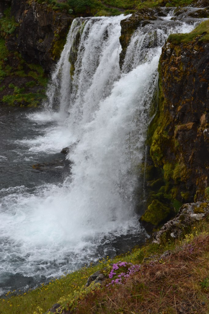
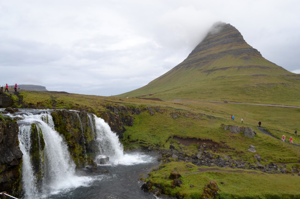

But I digress, we had places to go!! First stop was a return visit to Kirkjufellsfoss. The tide was low this morning, and we could traverse the path to the falls themselves. It’s not a particularly large waterfall, but the river here falls in two separate cascades that are almost as wide as they are tall, and the effect is quite beautiful. A trail leads up one side of the river, across a small bridge that spans the river above both drops, and then back down to a viewing area on the other side. It’s from this vantage point that one of the most famous views, anywhere in Iceland, can be found. The real beauty of Kirkjufellsfoss is not necessarily the falls themselves, but the view across the falls, framing the conical Kirkjufell in the background. Any search on photos in Iceland will inevitably reveal examples of this view – summer, winter, under the northern lights, in the snow – you name it, it’s gorgeous. Even under our cloudy skies, we had to agree.

Kirkjufellsfoss was also our first experience with disrespectful tourists. The area here was clearly marked – with low rope fences – as areas of “trail”, and “not trail”. In tundra areas like this, the native plants are fragile, often living in a cryptobiotic crust that is easily crushed and eroded away. Unfortunately, we saw several instances of people ignoring the restrictions here, and stepping OVER signs and ropes to get to an off-limits spot from which they could take what they deemed the perfect picture. It is easy to tell what happens to the land here with a lot of human footsteps, and tearing up more of it for Instagram fame isn’t worth the damage done. This is why we can’t have nice things.
We would later see people standing next to “no drone” signs, while flying their drones along cliffs and waterfalls. In one instance, they reasoned to us that “it’s early, there’s nobody here, I’m not bothering anyone.” I contend that the nesting seabirds on the cliffs vehemently disagreed. Point being, it’s not always about people, and it’s certainly not always about YOU.
Sorry, rant over. Head west…
We soon entered Snæfellsjökull National Park. There were no gates, no entrance fees charged – just an unassuming sign on the side of the road to let us know we had passed an invisible boundary. Just inside that line, we left the highway for a short side-trip to Skardsvik, a beach area on the coast. This is actually one of the few beaches around that is NOT black sand, but white. It actually looked odd to see “normal” sand surrounded by volcanic rock. It provided some opportunities for us to explore, and go dip a hand into the waves of the North Atlantic for the first time. (Spoiler: it was cold).

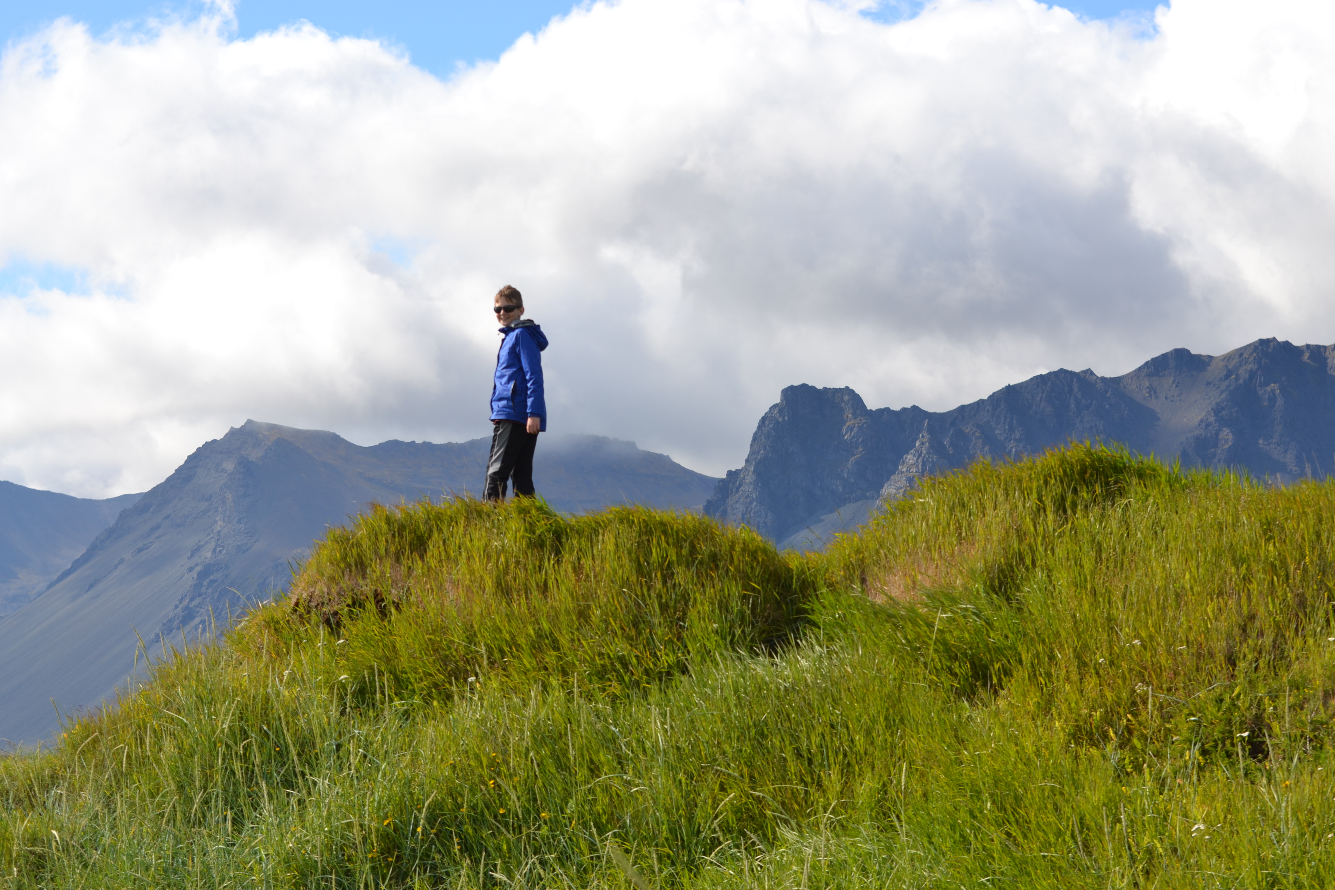
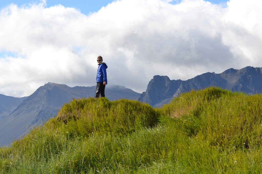
Farther west, we decided to investigate Saxhóll Crater. Driving through the tundra and grassland, I had just started to re-calibrate my sense of distance and size. As I do every time I venture to the deserts of the western US, I realize how much I subconsciously rely on trees as a reliable size and distance reference. When trees get removed from the landscape, it takes me a while to realize that most of what I am looking at is both much farther away, and much larger, than my senses would have me believe. Such was the feeling I had driving up to Saxhóll. It’s a conical cinder cone that is a very accessible way to get in touch with Iceland’s volcanic nature, with a path that is part trail, part staircase spiraling up its face to the crater at the summit. From the main road, it was readily visible, and looked relatively small, and nearby. But… my eyes deceived me. Compared to the mountains around us, and certainly Snæfellsjökull, Saxhóll is small, but as we made our approach, Saxhóll seemed to grow, and grow, until it was no longer a small cone, but a substantial climb. In for a penny, in for a pound, as they say – up we went!
Up close, it’s clear that Saxhóll is a pile of volcanic talus. It’s easy to picture small blobs of lava being thrown into the air and landing in a heap. The conical shape of the mountain is governed by the slump angle, the maximum slope the mountain could achieve without additional pieces rolling and sliding down the hill’s face. It’s like pouring salt, or sand or gravel into a pile, on a much larger scale. This implied that the lava granules were at least semi-solid before landing here, and one could infer that this was once a fountain of molten rock. On top, we found ourselves on the lip of a large bowl. Toward the east, Snæfellsjökull loomed, towering over the equally impressive mountains that surrounded it. In truth, it wasn’t until this point that we realized the mountain was there – its glaciated peak was covered by cloud, and it blended in so well as to be nearly invisible – but once we realized what we were looking at…. let’s just say I’d like to revisit this vantage point on a clear day!!

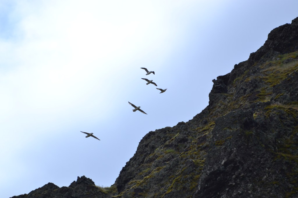
Near Saxhóll, we spotted a tiny church nestled all alone in a steep-walled valley of mountains at the foot of Snæfellsjökull. The degree to which this church was dwarfed by the landscape was impressive, so we pulled off on a small gravel road to get a photo – and that’s when we were attacked. We didn’t immediately recognize the assault for what it was – fifty or so Arctic Terns took flight out of the lava-strewn grasslands and started hovering over us. Some established high orbits while others held position at thirty feet up, and stared. In our naivete, we didn’t fully appreciate how infrequently visited this area was, and so our first thought was to (unfairly) equate the terns to seagulls back home – our instincts told us they were looking for food. In retrospect, I’m ashamed that was my first reaction – and it just goes to show that regardless of my intentions, I live my life in a human-centered universe where my first assumption is that the animals were happy to see us and ready to beg.
Nope. This was an attack. The birds soon started taking turns dive-bombing us. They would arrest their dives a few feet above our heads (much closer when our backs were turned) with a threatening squawk. We didn’t see them, but there must have been nests nearby among the rocks, and we were definitely not welcome here. What amazed me was that the entire flock was rallying to the defense of the few birds whose nests were on the perimeter of the colony, near where we’d parked. This was definitely a collective effort – and fortunately they were willing to let us off with a warning. No pecking occurred, and as a result, we were free to apologize through laughter at the situation, get back in the car and leave the birds in peace.

Arctic Terns, it must be said, have the longest migration route that we humans know of. Every year, they travel from the Arctic, to the Antarctic, and back, seeking out polar summer on both ends of the Earth. As a result of this exertion, we were later told by an Icelander, “These birds are always ticked off at something…”

Rounding the corner to the south shore, our next stop was a black sand beach named Djúpalónssandur. At one time, this was a busy, productive fishing village, home to some sixty boats. Now, it lies within the National Park, and is home only to lava hoodoos, sea stacks, a broad expanse of black sand, and the rusty remnants of a maritime disaster from 1948. In March of that year, a fishing trawler from England, the Epine came ashore among the rocks here, and the residents of the local village mustered to help save the crew. Unfortunately, few survived.
Among the volcanic spires lining the trail to the beach, we also found several heavy stones, worn round and smooth, like oversized river rocks. Apparently, these stones are like those used to test the strength of those who desired to work aboard Viking longships. By lifting a stone onto a waist-high platform, you could either demonstrate that you were of “full strength”, “half strength”, a “weakling”, or “useless”. I couldn’t help but note that “Useless” was the label applied to those who lifted the smallest (23 kg) stone, suggesting that if you chose not to make the attempt, you were even worse than useless. We gave it a go, and, at least based on the sign, I could have qualified as a rower, and one of my sons was a “weakling”. The other, diplomatically, chose not to risk being compared to his brother, and simply stated that a life at sea was not for him. We avoided applying any labels to this decision!

Continuing back east, our next stop was at a nondescript gravel lot at a trailhead that led north toward the ever-present cliffs. This was Rauðfeldsgjá, a slot canyon that appeared to be no more than a vertical crack in the cliff face. After a half-mile approach, it became apparent that the small creek flowing down from the mountains here was actually flowing out of the crack. Overhead, several species of seabird circled to and from nest sites in the cliff face, hundreds of feet up. The entrance to the canyon required a ninety-degree turn and walking through a slot that was completely occupied by shallow creek (only a few inches deep), before emerging in a chamber, perhaps twenty feet across, lit by sunlight streaming in perhaps three-hundred feet overhead. Continuing upstream, we clambered over boulders and up small waterfalls in a slot that was perhaps only five feet wide, dark, but adequately lit by sunlight shining through the crack far above and reflecting off the walls. The sound of the creek echoed off the walls, generating a persistent background roar.


This place was fantastic. Not for the last time, I felt like I was in the video game land Skyrim, but of course this was much more real. After some exploration upstream, the boys and I turned around to head back downstream, and fortunately did not encounter any wandering draugr in the process.
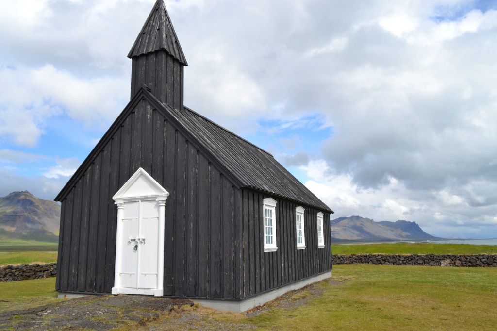
Next stop, Búðir, a small community that lies on the mostly-flat volcanic plain that stretches between the cliff and wall of mountains to the north, and the ocean to the south. Búðir is most well known for its unique church, a small, jet-black structure with white trim called Búðakirkja. This was at least the third such church we’d seen – meaning, a small wooden chapel set, seemingly, all by itself in the middle of nowhere. This one is unique because of its paint scheme, but we had to admit that the church and its surroundings were both striking.
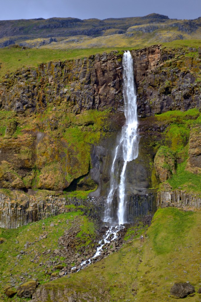
Right across the main road from Búðakirkja, Bjarnarfoss tumbled off the cliff face. This was one of many waterfalls along the cliff that drained the upper plateau and the high peaks above, but this one had the advantage of a good vantage point near the main drive, and so it got a name and a callout on the map. They’re ALL beautiful, but waterfalls are so common here that they almost occupy every view toward the mountains. We never got tired of looking, but it was (at times) difficult to determine why one would be on the map, and then the other four within a mile of it were not.
We left Búðir looking for a seal beach named Ytri Tunga, but after some driving we realized we must have passed it. It was mid-afternoon by this point, so we stopped in to grab a late lunch at a small motel/inn and cafe called the Rjukandi Cafe, where the owners confirmed our mistake. There had been a sign, but it had blown down last winter and not replaced – instead we got directions based on a cluster of mailboxes, and we reversed course for a few miles to find Ytri Tunga.
This area isn’t so much a beach as a jumble of rocks that reach the ocean, but the rocks form several shallow pools and lagoons that are protected from the waves, and provide a safe harbor for seals. In a freshening breeze blowing from the south, off the ocean, we walked along the shore, over and through the jumble of rocks. Occasionally, we’d see a curious face pop out of the water – a grey seal! There weren’t a lot of other people here, maybe ten or so, but when you see a group of any size gathering and pointing, it’s generally a clue… so we made our way out onto a spit of rock that formed the edge of a small lagoon, where a small group of people had gathered, and were pointing.
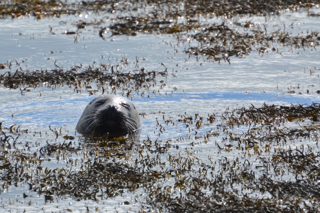
There were three seals hauled out together on the rocks, in what our boys called “taco mode”. During a trip to southern California years ago, they noted that when seals are resting on their sides, their heads and tails tend to curve toward each other in a slight crescent, and that often, the seals lay with their eyes closed and what appears to be a smile of contentment. Why this shape immediately invoked the thought of tacos, I’m not sure, but that’s an accepted lexicon in the family now, and we’re sticking with it.
In addition to the resting and basking seals, several others were swimming around, occasionally popping their heads up to look around. We spotted another seal laying in a floating mat of seaweed that was thick enough to mask the animal’s outline. Another was laying on a rock that was just barely protruding from the surface. The tide must have been coming in, because over the next twenty minutes or so, the number of waves that breached this island seemed to increase. Each time water would wash over this perch, the seal would turn and look seaward, as if annoyed. We became engaged in this drama between sea and sea creature, and watched until the waves were big enough to wash over both rock AND seal. The seal held its ground for a while, but eventually gave up and rolled off the rock to look for a better perch.

Ytri Tunga turned out to be our last nature exploration stop of the day. We still had some ground to cover, to make it back to Reykjavik for the night, so we hopped into the Duster and hit the road once more. This time, we got to see all the scenery that had been lost in fog during our arrival, and we rode mostly in silence, taking it in.
In Reykjavik, we found our hotel Brim, which is set up a more like an Inn than the US standard hotel. Rooms were fairly small, but sufficient, and down the hall there was a sitting room/game room/library, a common kitchen, and a communal dining room. We settled in a bit then walked down the street to a nearby Krónan grocery store where we not only navigated signs and labels in Icelandic, but then managed to work our way through a self-checkout with written and verbal instructions in Icelandic. Mission accomplished along with a little humility on being strangers in a strange land.
We made our way back to Brim and had dinner there in the kitchen – I didn’t make note of exactly what, but I remember it was something simple, that required basic cooking, and that the boys did a great job both making it, and cleaning up after. It was nearly 11pm when we were done… so we stayed up to watch the sun set, almost due north, at 11:40-ish, knowing it would rise again in less than an hour.
A busy day. Next, home base is in Reykjavik, so we hit the primary tourist sites, plus a few more out of the way places along Iceland’s Golden Circle!
Footnote: Though this writeup hits the highlights, I have a video on YouTube through the link below that fills in some gaps and gives a sense of the scale of some of these places in a way still photos can’t (like the aggression of terns, or the interior of Rauðfeldsgjá)! The converse is true as well, but then I presume you’ve already read this version. Check it out!
Get Out There
Troy

Excellent photos. I’d like to go sometime.
LikeLiked by 1 person
Thanks, and I hope you do! Beautiful place… although to be honest I’d be happy to go almost anywhere these days!!
LikeLike