This is part six in a series outlining my family’s exploration of Iceland during the summer of 2019, pre-COVID. It was a mostly outdoor experience, exploring the wild and natural sights of a beautiful country during the height of summer. For the full journey, and notes on places to go and things to see, check out the other posts in this series.
- Prologue
- Part 1 – Grundarfjörður
- Part 2 – Snæfellsnes
- Part 3 – Golden Circle
- Part 4 – Roaming in Reykjavik
- Part 5 – Landmannalaugar
- Part 6 – Southern Coast
- Part 7 – Jökulsárlón
- Part 8 – Departure and Epilogue
It was time to bid farewell to Reykjavik.
We were moving east, in search of new places to explore, and we were to exceed the reasonable radius to make a day trip out and back to the city. So we packed up, enjoyed a few final, tiny cups of strong coffee, and drove east.
(A parenthetical aside here – tiny cups of strong coffee, not quite espresso, was something I never got used to in Iceland. I’m definitely not a coffee connoisseur, and will admit to preferring quantity over quality. Perhaps that’s an American view, but for me, drinking coffee is an event. I drink it black, and I enjoy a large cup from which I can draw generously over a period of time. I enjoy the warmth and bitterness more than the caffeine. These Icelandic shot-sized cups, meant for sipping, are incompatible with my approach, uncultured swine that I am. I’d all but chug these things, and then feel somehow let down that it was gone so soon…)
The easternmost point of our day’s journey was the town of Vik, a small town near the southernmost point of the island. If our original plan for a late-winter trip had panned out, Vik would have been a major base of operations for exploring glaciers and other adventures. For our summer plans, however, it was to be just a waypoint, a half-day’s drive away. We would aim to hit Vik for lunch, and then work our way back west to our new accommodations, a small cabin near Hvolsvöllur.
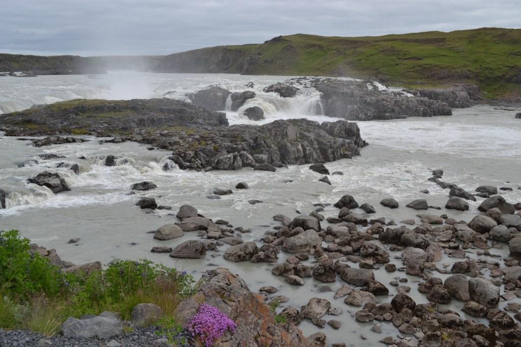
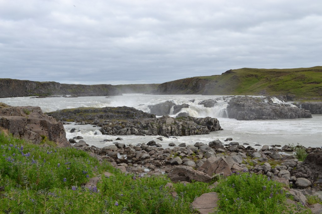
The first part of our journey, between. Reykjavik and the town of Selfoss, was familiar. Beyond this point, we entered new territory, and made our first stop where the highway crossed the Þjórsá River (Thyor-sa), Iceland’s longest. Just downstream of the bridge here, the river falls over a series of ledges to form the roaring Urriđafoss. While not the tallest falls we had seen (or would see), Urriđafoss holds the distinction of being the largest in Iceland, as measured by volume of water.
Fishermen lined the banks downstream of the falls, pulling in large fish, some trout and some Atlantic salmon. Alas, I didn’t get any pictures, but I would have been extremely proud and happy to land even the smallest fish I saw caught that morning.
Beyond the Þjórsá, the highway entered a seaside plateau bordered by the Atlantic on one side, and high glacier-carved cliffs on the other. Thin, wispy waterfalls plummeted off the cliff face. They were everywhere, so commonplace as to not warrant names. Farms, tucked up against the cliffs, dotted the landscape and served as apparent homes to the sheep that seemed to wander at will across the landscape. More than once, we had to slow or stop to let sheep cross, or at least get out of, the road. It was gorgeous.
Nearing Vik, the narrow shelf between cliff and sea became narrower, so that the road was forced to climb up and over, before dropping down a steep valley into the town itself. The cliffs here, now seaside bluffs, were able to catch the moisture coming off the ocean. Trapped between the ocean, the mountains, and the cold glaciers just out of sight to the north, this moisture coalesced into localized, persistent low clouds and occasional rain, the first we’d seen since first arriving in Iceland almost a week ago.

We arrived in Vik shortly before lunchtime, and found an open cafe where we grabbed a quick bite of warm seafood soup before heading out onto Kirkjufjara (“Church Beach”), a wide black sand beach between the town and a large cliff. The headland extended all the way to the ocean before ending in an abrupt drop straight into the crashing waves of the North Atlantic. Just offshore from the point, a series of high basaltic columns protruded from the ocean, stubbornly refusing to fall into the sea.
These sea stacks, collectively, were called Reynisdrangar. According to legend, two large trolls ventured offshore here to fetch a foundering three-masted ship, and proceeded to tow it back to shore. Unfortunately, as so often happens with trolls, they miscalculated the time their effort would take, and were caught by the rising sun. As the rays of dawn struck the trolls, they, and their ship, turned to stone, and here they remain.

We wanted to get closer, so we drove back west from Vik, over the headland, and back out to the shore on the far side of the point. The beach on this side was called Reynisfjara, which roughly translates to “beach of the endeavor”, or “beach of the effort”. A reference to the trolls’ task, maybe?
Reynisfjara was full of people, but it was not hard to see why. The cliffs at the foot of the headland here had solidified into hexagonal columns of basalt, a geologic tell-tale of volcanic activity, and the cliff had been carved by the waves to form impressive caves. The cliffs above were bustling with activity, as puffins would launch themselves off grassy nest sites and out into the ocean, just as others would return, presumably to feed chicks. Puffins are surprisingly fast, and their wings beat quickly to support their round bodies – an evolutionary tradeoff between aero- and hydrodynamics meant these birds had to work hard to fly, if they also wanted to use the same wings to dive and swim.


Signs along the beach warned of “sneaker waves”, occasional rogue waves that would pile up and break along the beach here with little warning. I’ll admit, we underestimated the risk ourselves. It was near low tide during our visit, and the beach was ample. But, we understand that several weeks after we left, a surprise wave crashed ashore and closed the gap, all the way to the cliffs. Blissfully unaware of the real danger here, we walked out to the point, watching puffins overhead, to get a good look at the trolls – Reynisdrangar – from a close distance.

We spent a long time on Reynisfjara. The geology was impressive, and the puffins were entertaining. On one hand, it was a black sand beach, but once again, Iceland was serving up landscapes completely new to us, and we ate it up.
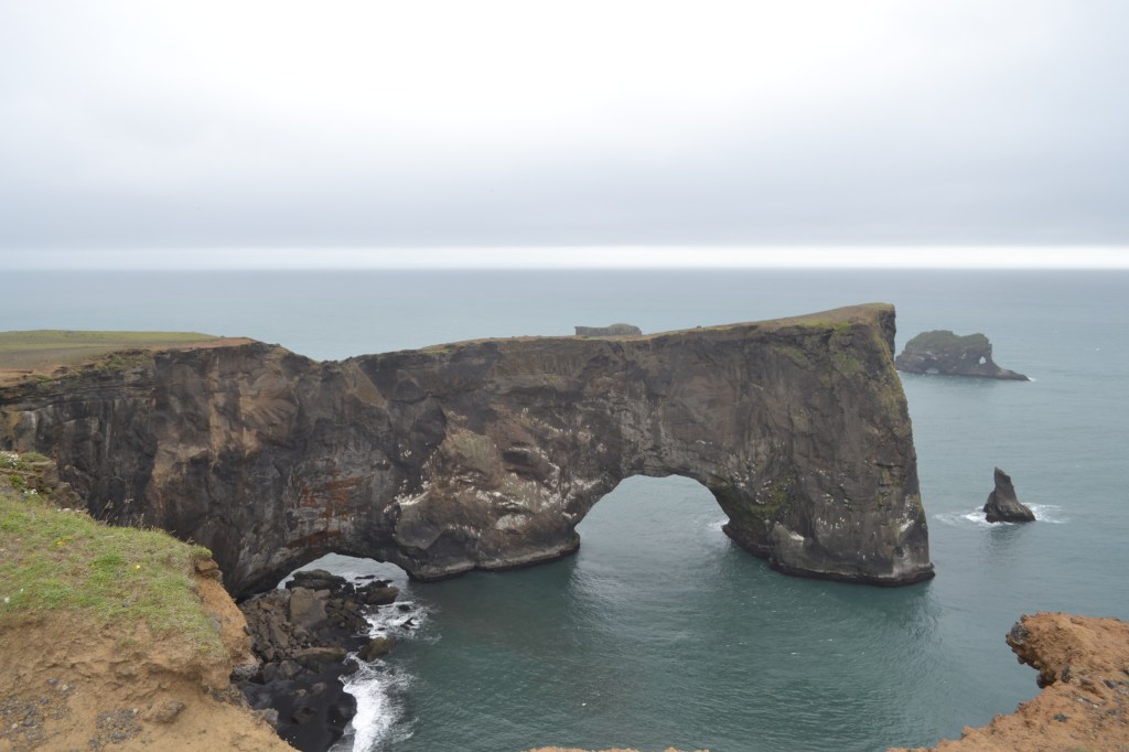
Eventually we did move on, and made our way to the next headland to the west. Here, as at Reynisdrangar, the headland extended into the sea, but rather than leaving sea stacks offshore, the sea had carved a tunnel directly through the cliff. The resulting arch, called Dyrhólaey, is viewable both from the beach and the top of the cliffs, but we found the best views to be from the top of the headland adjacent to the Dyrhólaey Lighthouse. Unfortunately, we arrived just as a wave of wind and rain lashed the hillside, and the temperature dropped suddenly. The wind was furious, but we still marveled at the view of the ocean-carved rock and the surrounding beaches before retreating back to the car.
Inland, and back down at sea level, we made another stop to investigate a cave opening high upon a rocky bluff. Lynn elected to sit this one out, as the boys and I scrambled up a steep face, pelted by rain and scolded by circling sea birds, to reach the cave, called Loftsalahellir (“Attic Cave”). The cave was not deep, but it provided immediate shelter from wind and rain, and it was surprisingly full of bright green ferns. From this vantage point, we got some great views out through the dark opening, toward the coast beyond.

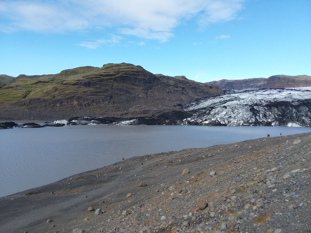
Making our way back west, our next stop was at Solheimajökull (“Sunrise Glacier”), one of the few glaciers accessible from the highway along this stretch of coast. Away from the headlands around Vik, the weather had cleared again, and the sun shone brightly as we walked up to the toe of the glacier (or, as close as safety would allow). The meltwater lake at the glacier’s toe was full of icebergs and kayakers, and an outfitter adjacent to the parking lot offered hiking tours and snowmobile excursions farther up the glacier itself. The folks here informed us that, back when the business was established, 18 years ago, it had been placed adjacent to the glacier’s toe. Now, the glacier was 3/4 mile up the valley. It had receded significantly, and its pace was accelerating. Icelanders have a daily reminder of the effects of climate change.

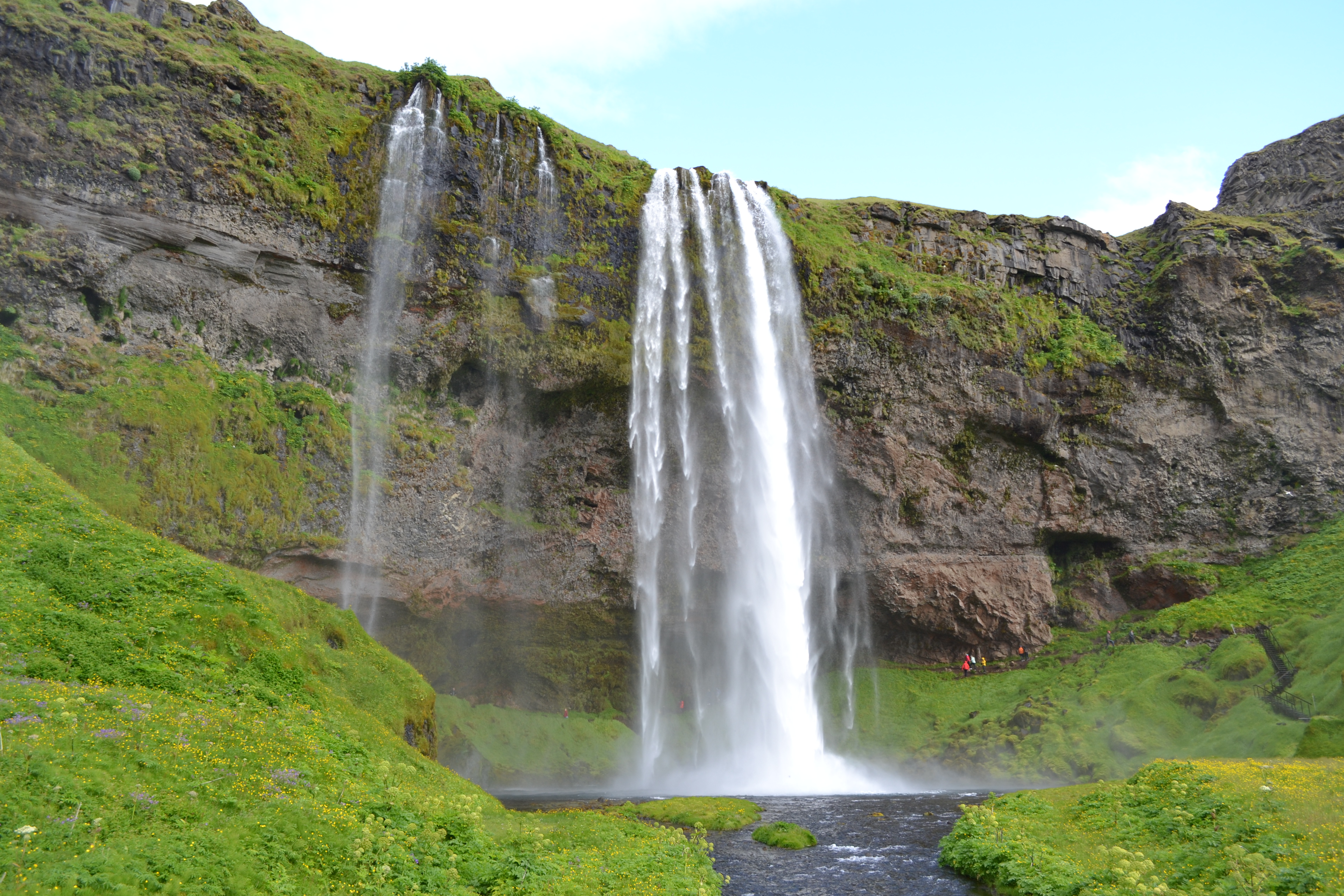
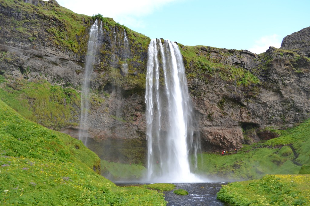
Further along, we made another stop at Skogafoss, an impressive (and frequently photographed) waterfall and park in a cleft along the coastal cliff. Skogafoss plummets 200′ (60m) off the cliff in a solid curtain 80′ (25m) wide. It falls into a small stream that seems impossibly shallow. Here, if you’re brave enough to face the impressive amount of mist and spray, you can walk almost directly to the foot of the falls, and surround yourself in rainbows. Alongside the falls, a stairway switchbacks up the cliff. These stairs also mark the end of the optional extension to the Laugavegur (yes, I have to come back here and make that hike someday).
Nearby is another impressive waterfall, Seljelandsfoss. The size and water volume here is similar to Skogafoss, but the cliff here is undercut into a cave that allows visitors to walk behind the falls. It’s a unique experience, and very much worth the walk.
By the time we’d completed our trek behind Seljelandsfoss, we were getting hungry, and tired. So we made our way to the Kronan grocery in Hvolsvöllur, and bought ingredients for dinner before seeking out our cabin. The house was situated in a small forest – or what passed for a forest here in Iceland – and behind a gate we were warned to keep shut unless we wanted to become employed as impromptu shepherds to remove the wandering sheep that would invade. The cabin was actually two structures – a living and cooking area, and a separate bedroom – connected by a breezeway and surrounded by a wooden deck.

On the horizon, the volcano Eyjafjallajökull loomed over the valley. Inside, a framed photo showed what Eyjafjallajökull looked like during its 2010 eruption, as viewed from the cabin. It was ominously close, and prompted a short discussion (in jest) about the wisdom of booking lodging in a volcanic blast zone.
It had been a long day, and we settled in, relieved to have a new home, and that it was such a nice spot. We cooked a pasta dinner and listened to foreign (to us) birds and insects call from the small trees and grasses that surrounded our cabin, happy to be out in the countryside as the sun dipped low. We’d never see a truly dark night, but this was our first exposure to anything like night in Iceland, while away from civilization. It was nice.
Next time, we take advantage of our more easterly base camp to stretch even farther east – to the glacier lagoon at Jökulsárlón and to Skaftafell National Park.
Get Out There
Troy

Those waterfalls are amazing. 😊
LikeLike
They really were – and they were literally EVERYWHERE.
LikeLike
Wow! I hope I can get there one day. 😊
LikeLike
Thanks for the posts. It has been interesting.
LikeLiked by 1 person
Clearly one of those situations where I’m recording for my own sake, but happy to share and glad others are interested!
LikeLike
I totally agree. Posting gives you a good way to relive those memories.
LikeLiked by 1 person
I shared your part 6 with my daughter. They’re planning a possible trip to Iceland as a graduation gift for their daughter as she finishes college.
LikeLiked by 1 person
That’s great to hear! If I were to go back NOW, I’d have to make sure not to miss the opportunity to see and get up close to an actively erupting volcano, out near Keflavik. That would make for a very unique trip!
LikeLiked by 1 person