I’ve been writing a lot about Astronomy, but aside from the neat rare events or cosmic coincidences, there’s a reason why understanding the night sky is important to kids of all ages spending time outdoors: awareness of time and place.
The speed of movement in the sky is pretty predictably driven by Earth’s rotation and revolution – 24 hours of spin drives the sky around 360 degrees per day, and 365 days (one year) drive the the apparent position of the sun across the constellations 360 degrees in a year (almost exactly one degree per day). There are other complications – tilt of the Earth, your position ON the Earth, movement of planets… and of course there’s the monthly clock provided by the orbiting moon. Understanding trends and long-term movements certainly helps with awareness, but we can ignore a lot of these subtleties and boil things down to a few handy tricks.
If you’ve read any of my Astronomy blogs, hopefully you’ve already picked up a thing or two – but here’s some specific, simple ways to use the sky to find your way.
How Long Before Sunset?

About 2 hours to go!
Knowing the angular rate of movement (360 degrees/24 hours) leads to some easy approximations of angles – all you need is a consistent reference. Hold your palm towards you, with your arm stretched out as far as you can reach, and you’ve got your reference. Each of your fingers is about 15 minutes of movement wide, meaning all four fingers together are about an hour.
Measure between the horizon and the sun, and this is a pretty simple way to figure out how long you’ve got til you start losing light.
Sundial
If you’re in place for more than a day, make a sundial. You probably don’t really care about actual hours, but things like sunrise, sunset, mid-day, mid-morning, etc are all useful in estimating how time is progressing.
Find a smooth piece of ground where shadows can be sharp and not interrupted by grass, etc. and plant a stick in the ground vertically. Now start paying attention to shadows, using small rocks (or anything else not subject to being blown or washed away), to mark the end of the stick shadow as it progresses.
Sunrise and sunset ought to be fairly obvious! The shortest shadow marks mid-day. And you can evenly subdivide the remaining gaps to mark those times you care about. If it’s close to an equinox (roughly March 21, Sept 21), and your days are about 12 hours long, you can actually mark hours, if you want. But this kind of precision is a luxury, not really a requirement.
3 Stick Shadow Methods to Find Direction
#1 – Sundial!
If you made a sundial, or at least have marked where the sun’s shadow is shortest, that’s all you need to know. That point where the sun is highest, and the shadow is shortest, is your North-South line. In the Northern Hemisphere and out of the tropics, the shadow points North. South of the equator, it points South. Near the equator, it depends on time of year (that pesky Earth-tilt thing).
#2 – Equal Shadow Lengths
 Again, using the setup of a sundial, take two measurements of equal shadow length – one in the morning, one in the evening. Use a string tied to the base of your shadow stick, and mark the length of your first shadow to make sure you’re finding the equal length point on the other side. The line between the ends of these two shadows will run East-West.
(Note, if you’re up all night and have a moon that casts a shadow, this same trick works, as long as you’re sure the moon passed through its “noon” equivalent high-point between your two shadow measurements).
#3 – Single Shadow-Stick
 Put a stick in the ground and point it directly toward the sun so it casts no shadow. Then wait long enough for the stick to cast a shadow about 6″ long (not strictly required, but more length gives more accuracy). The shadow from the bottom of your stick points East. (Note, this also works with a bright moon).
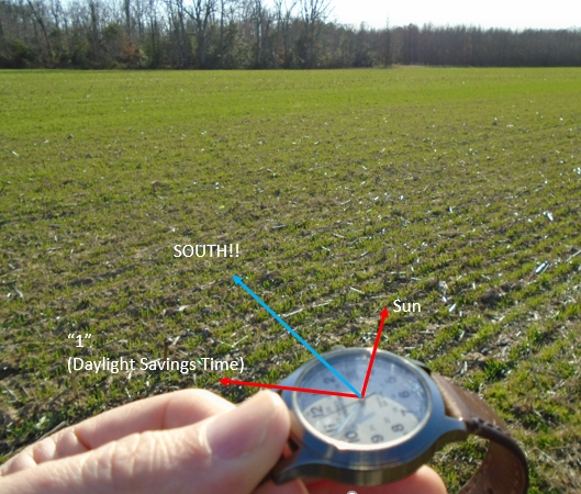
Analog Watch Method
 Using an analog watch – the kind with hands – point the hour hand at the sun. The line that bisects the angle (halfway) between the hour hand and “12” (or “1” if you’re on Daylight Savings Time) points South.
In the Southern Hemisphere, point the 12 at the Sun, and use the line halfway between that and the hour hand – this points North.
Celestial Navigation
At night, things get a little trickier, because all your references are light-years away. Finding North (in the Northern Hemisphere), is fairly easy – just find Polaris, the north star. I’ve written before about two easy ways to do this, using the Big Dipper and Cassiopeia. You can even approximate your latitude – it’s equal to the angle measuring the height of Polaris from the horizon.
The rest is a bit more complicated – star charts for celestial navigation take up volumes, because the position of the stars changes from night to night over the course of a year. Timing transits of stars for navigation was actually the main driver in advancement of accurate time-pieces. You couldn’t navigate the open seas and know your longitude without also knowing what time it was.
Given that, though, there are a couple shortcuts – but it takes some familiarity with a big chunk of sky. As one example, the signs of the zodiac conveniently number 12 (ignoring the newcomer Ophiuchus which doesn’t take up much space anyway). This means that you can picture the sky as a giant clock with each constellation representing a number on its face, but since the sky only goes around once per day (not twice like a clock), you can also count on it taking about 2 hours for a given constellation to move past a given point, or direction.
Using this knowledge, let’s take today for example (Feb 27). Right at sunset, Leo is rising. If that’s East on our “clock”, then the next few zodiac constellations will correspond to 30 degrees of heading change. The next are Cancer…Gemini…then Taurus will be 90 degrees off and therefore be South. You can use Aldebaran as a “South Star” approximation (or use it to pick a star closer to the horizon, like maybe Rigel), at least for a little while. Just remember everything’s moving and you will have to shift reference to Gemini/Sirius in an hour or so.
Knowing what the stars are doing at your location can actually help you pinpoint your location, and with a little understanding of the geometry of the Earth and its tilt and orbit with respect to everything else, you can visualize a lot of information about time, place and direction, just by looking at the sky. It’s another connection that our ancestors had, and that we’ve forgotten – but it’s extremely useful, as long as it’s not completely overcast!
Get Out There!
Troy
flying-squirrel.org

I just saw that finger/hand trick on figuring out approx how much more time until sunset on the History show “Alone!” I thought that was pretty neat. Hope I remember it. 😉
LikeLiked by 1 person
I still have trouble picturing the angles on why the single-stick shadow method (pointing stick directly at the sun) works, but it does – the tilt away from vertical effectively removing the “south” component of the sun’s position and translating the shadow to directly east-west. Great trick, but it hurts my brain! 🙂
LikeLike