
Most of us look at outdoor adventures – fairly or not – as a trial of personal skill and endurance against the uncaring challenges of nature. Even those among us who are more interested in immersion and exposure to nature tend to occasionally be proud of conquering a challenging peak, knocking down a large number of miles, or otherwise enduring some physical hardship. The truth is that this struggle is primarily with ourselves, with our own stamina and limitations, but we write the stories in our memories as if nature itself is the antagonist that we go to battle against, and hope to defeat, somehow.
One “opponent” we often overlook, however, is weather. Yes, rain happens, and particularly for long trips, the ability to predict and deal with weather situations can make or break a trip, pose significant safety hazards, and when successfully mitigated, may provide the same sense of accomplishment as summiting that grand peak.
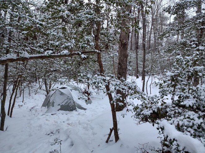
Dealing with weather in the backcountry can feel like a constant struggle against an unpredictable and potentially dangerous adversary. Unlike forecasts for populated areas, accurate weather data for remote backcountry locations is scarce and prone to significant variation, particularly due to mountains “making their own weather” and conditions changing drastically with elevation and geography. This makes the weather an unreliable foe, as forecasts are generally trustworthy only for about 5 days, and longer trips will inevitably expose you to more extreme and varied conditions, even if the overall long-term average is benign.
Sudden, Dramatic Assaults: All weather activity is driven by atmospheric lift, and faster lift can lead to more dramatic and severe weather changes. There are several mechanisms for generating this lift, leading to atmospheric instability and building weather.
Cold fronts are typically large-scale atmospheric structures where cooler surface air pushes up warmer air, causing significant uplift and often leading to severe weather with clouds and precipitation directly along and ahead of the front. In the United States, fronts generally move from west to east, and are marked by significant wind shifts. If you notice a building southerly or southwesterly breeze, chances are a front is approaching within the next 12 hours, and its passage may be marked by storms, rain, and strong, colder north and northwest winds after frontal passage.
Similarly, low-pressure systems actively cause air to rise, bringing clouds, precipitation, and wind. Depending on where they form, lows may deepen and pull in significant moisture – for example, along the east coast it is common for lows to form along weak fronts and slide northeast along the coast, becoming powerful Nor’Easter storms marked by cold, wet, and strong winds. If you have a baro-sensitive watch or other sensor that directly measures barometric pressure, and you notice pressure dropping (while you yourself are either at a constant altitude or descending), get prepared for worsening weather.
Storms can form in high pressure zones as well, driven by the uplift created by surface heating on a humid summer day. If conditions are “hazy, hot and humid”, you can expect cumulus to build into cumulonimbus clouds and afternoon summer thunderstorms that don’t move very fast.
Finally, mountains have a tendency to create their own weather, and high peaks and ranges generate microclimate zones that may have drastically different weather than the broader area patterns. Wind blowing up against a ridgeline will be mechanically forced upward, where it cools, and any moisture condenses out into clouds, fog, and potentially rain or snow on the windward side.
Note, in all these cases, we’re talking about uplifted, unstable air. The opposite situation, stratus clouds laying in long thick horizontal layers or a steady overcast, may bring steady long-term rain, but the situation is fairly stable. Sudden changes in these conditions aren’t likely.
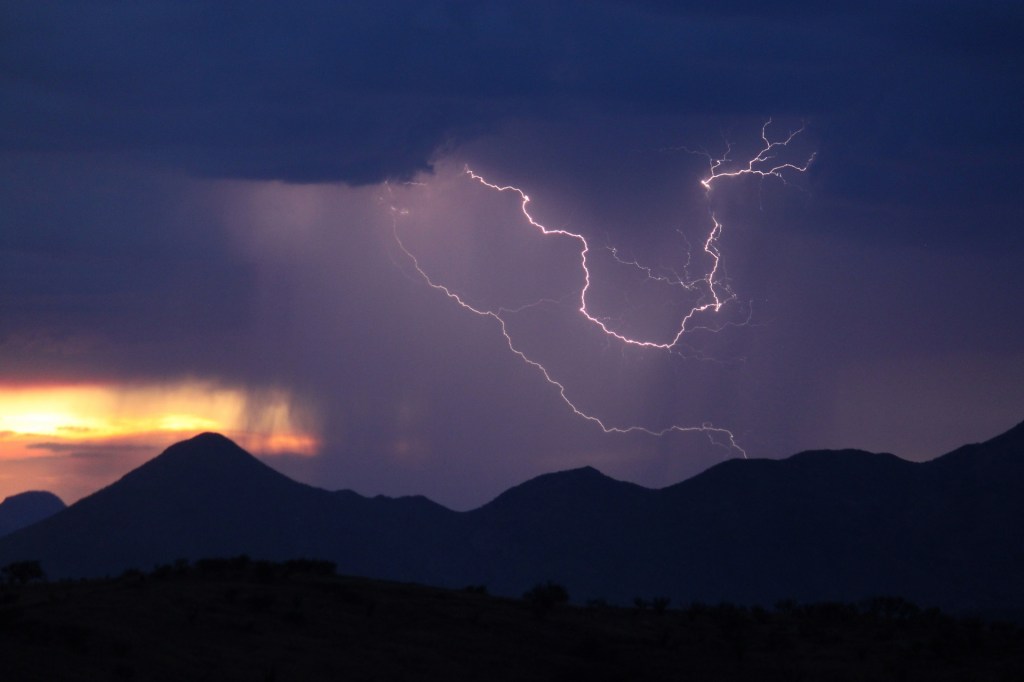
The Deadly Threat of Lightning: Lightning is a significant danger, accounting for around 50 deaths in the US annually. It can strike up to 30 miles away from the center of a thunderstorm. Stay aware of lightning danger zones and stay away from exposed high-altitude ridge lines or peaks, or isolated high points, such as a group of trees in otherwise low terrain, and time your climbs to avoid high altitude during the periods of high storm probability in the mid-to-late afternoons. Remember that some summer storms don’t move fast, and they may be hiding just beyond a ridgeline, invisible but still dangerously close.
If you do get into a situation prone to lightning strikes, head downhill and look for cover quickly. Hikers must be prepared to minimize injury by assuming a “lightning crouch” if caught in a storm, as lightning can remain a danger for up to half an hour after the last thunder. Crouch, hug your knees, and balance on the balls of your feet with your feet as close together as possible, and on an insulating surface (like a ground pad) if possible. This makes you a small target, and minimizes the area of your contact with the ground, reducing the voltage potential between your contact points. It may be a long, scary wait, but hunkering down and letting the storm pass may be your best option – it’s very difficult to “outrun” lightning once you’re in a strike zone.
Deceptive Temperature Swings and Powerful Winds: Temperature changes can be tricky to predict. A sudden warm-up on a chilly day can signal a warm front and the risk of severe thunderstorms. Conversely, the arrival of a powerful cold front can cause temperatures to plummet rapidly, endangering those without adequate gear. Clear, dry nights tend to get colder, quicker, than overcast nights where the clouds prevent radiation of heat away from the surface – so if it’s a great night for stargazing, count on a colder night. Also, keep in mind that the standard temperature change with elevation is 2 deg C per 1,000 ft. (Yes, I’m mixing units, but this is an easier relationship to remember). On a given day, the actual temperature change as you climb may be higher or lower, but this is a good rule of thumb. So if you have a temperature forecast for a town in the valley, adjust accordingly to account for your elevation.
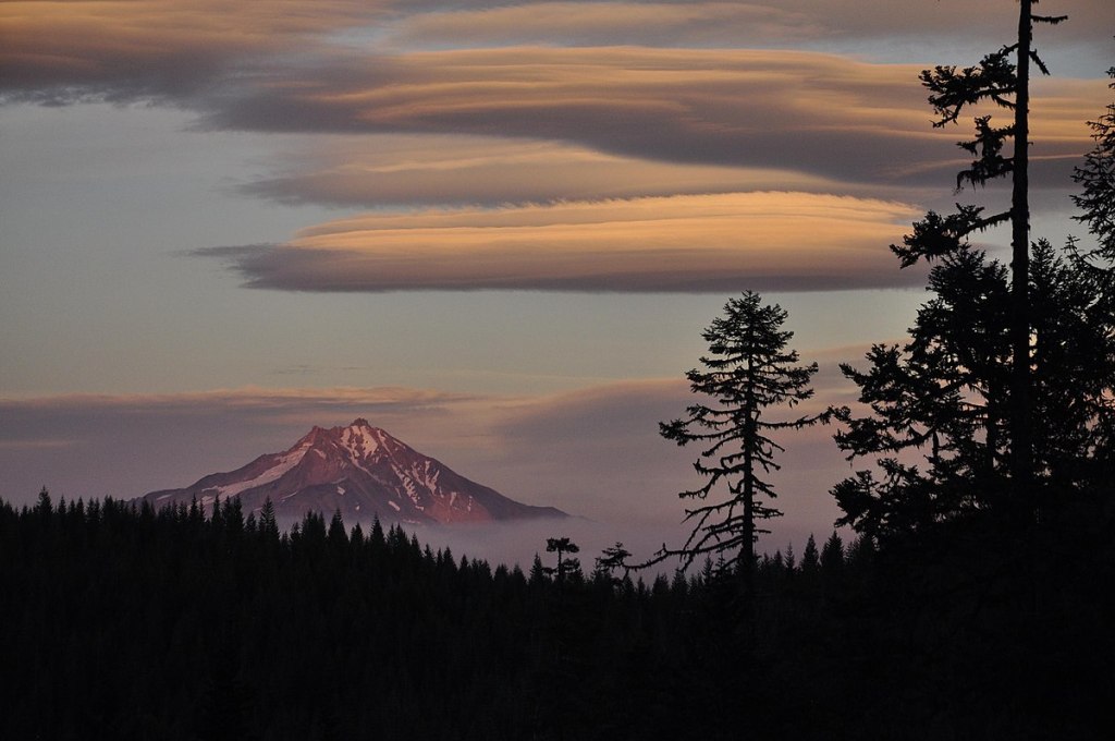
Wind is another invisible but potent adversary, often underestimated by hikers. Winds will shift and strengthen around fronts, as previously described, and will generally increase with altitude. If you see lenticular clouds hovering over a mountain summit, steer clear. These lens-shaped clouds are generated by accelerating, deflected winds over terrain, and are indicative of extremely strong winds. Winds of 35 mph make walking difficult and bend large trees, while 50 mph winds can break branches and make standing nearly impossible. At 65+ mph, wind can uproot large trees and even blow over trucks.
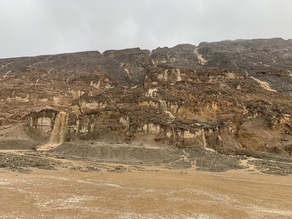
The Unseen Danger of Flash Floods: Flash floods can occur with very little warning, when heavy precipitation occurs anywhere within the watershed of a stream. Generally speaking, creeks will rise more quickly in steep-sided gorges and canyons, places where water has limited area in which to spread out. Some of the most dangerous flood conditions can occur in arid desert environments. In these areas, heavy rain on impermeable soils can cause water to travel for miles downstream in dry riverbeds (arroyos) or slot canyons, catching unsuspecting hikers off guard with tragic results. These events can take place even on sunny, clear days. In some cases, heavy thunderstorms many miles away can generate a flooding wave that may not reach your location for hours, so it is vitally important to monitor weather conditions not only for your location, but be aware of storms within the entire watershed.
Fortunately, I’ve never been caught in a flash-flood event, but I’ve certainly been in places where overnight storms caused creeks to swell to a degree that crossing them and escaping my particular location became a significantly more difficult concern.
I think it’s fair to say that many backcountry explorers don’t look at weather trends beyond the latest area forecast, and maybe specific forecasts at a nearby town or two. But in order to contend with long-duration stays or moving through complex micro-environments, backpackers and other adventurers need to learn to become their own meteorologists. This involves constantly observing nature’s signs such as clouds, atmospheric pressure changes, and wind shifts. Recognizing specific cloud types can reveal increasing moisture, instability, approaching fronts, or imminent thunderstorms. Observing pressure changes with a sport watch barometer can indicate incoming cold air or significant weather shifts. Ultimately, preparing for the backcountry means equipping yourself with appropriate gear and skills for the variable conditions, understanding that the weather will inevitably do one of three things: stay the same, deteriorate, or improve.
Learn local patterns, and prepare for weather to be a potential adversary on your next trip. Watching the developing and changing conditions will keep you safer, and may increase the overall sense of accomplishment you’ll have when the trip is over.
Get Out There!

It’s crazy how quickly the weather can change in the mountains. Love the shot of the lenticular clouds.
LikeLiked by 1 person
Thanks, I like it too, but that’s a public domain image from the National Park Service taken to document the wildfire smoke. The lenticulars are just a bonus!
LikeLiked by 1 person