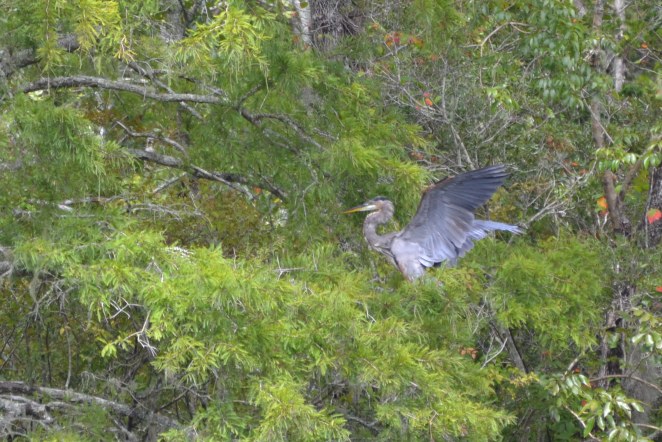
Far off among the trees, a pileated woodpecker drums on a dead snag. Turtles abandon their sunny logs and disappear into the dark water. Butterflies flit over a half-acre of pickerelweed, marsh mallow, and cardinal flower blooms, while a great blue heron stands in the shallows, looking to catch its next meal. The water, stained by tannins from the forest leaves, is the color of dark coffee, and is a perfect mirror for the bald cypress and blue sky.
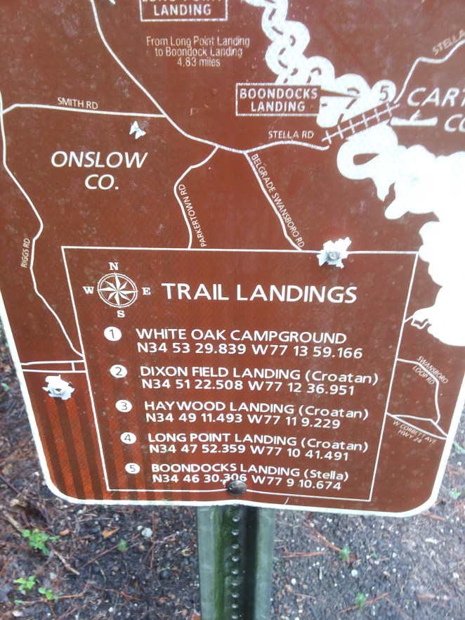
 This is the Onslow County White Oak River Paddle Trail, a 17.2-mile stretch of the secluded White Oak River, connecting 5 landings through the Croatan National Forest in southern North Carolina. Along this run, the river transforms from a narrow “blackwater” creek among cypress swamps to a large tidal river, not far from the Atlantic.
We recently discovered this area while on vacation in nearby Emerald Isle, and enjoyed a day in kayaks, paddling the central section of the river near Haywood Landing. It proved to be an extremely quiet, secluded and wild river, and a great change of pace from hanging out on the beach.
 I can’t comment on each of the five landings, but we personally visited three of them. The trail begins at the White Oak Campground (map and GPS coordinates available HERE) where the river is narrow and moving relatively quickly. Just under 5 miles downstream, Dixon Field Landing sits on a tributary creek, under a dark and close tree canopy with a brisk current.
Just under 6 miles farther, Haywood Landing, where we began our journey, is in a more open section of river, and includes a boat ramp – here the river is deep and wide enough that it is accessible by more than just paddlecraft. There is still a perceptible current, but at less than half a knot, it’s easily overpowered. We started here and worked our way upstream about 2.5 miles before turning around and coasting back. (Trip GPS data here).
If you want to see a representative sample of the river based on our trip – check out my video on YouTube, linked below.
 Below Haywood, about 3 miles down, Long Point Landing offers paddle-craft access along a railroad tie bulkhead and steps built into the river. Finally, the trail ends just as the river becomes a large tidal estuary, at Boondocks Landing just upstream of the Stella Rd. bridge.
Each of the landings provides ample parking and toilet facilities (at least, I can verify that Dixon Field, Haywood and Long Point all have enclosed sanitary latrines in a small building). However, getting to these mid-run landings takes some effort. Each sits at the end of dirt-road access through the Croatan National Forest, and during our trip in late August, these roads were full of potholes and washboards – particularly the road to Dixon Field. We were able to make Haywood and Long Point (carefully) in a minivan, but Dixon Field was challenging even with a high-clearance pickup.
 The river is worth the effort, though. The dark, tannin-stained water acts like a perfect mirror for wildflowers among the cypress knees. We saw turtles, herons, woodpeckers, and an alligator – though in fairness that ‘gator (about 5 feet) was sitting alongside the access road and not at the river itself.
With so many access points, this river provides an easy opportunity to delve into solitude and wilderness very quickly. You can spend an hour exploring, or drift all day. Either way, it’s a beautiful way to explore the wild bottom land of coastal Carolina.
Get Out There
Troy
http://www.flying-squirrel.org