
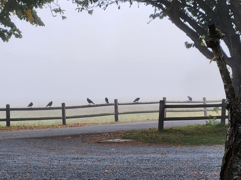
We woke up in a dense fog. The night had been fairly quiet, the South Fork of the Stillaguamish was just barely audible through the walls of the van as the temperatures dropped and the fog rolled in. As we made coffee in the cold damp, a gathering of crows (murder!) appeared on a nearby fence, the only things visible in front of a large meadow. Was this to be the dreary Pacific Northwest day we’d dodged this whole trip?
We set out shortly after dawn, headed west and then north into the gray mist. There were mountains out there somewhere. Mt. Baker was somewhere just north, but even when the fog was thin it was clear that a dense layer of clouds was obscuring the view only about a thousand feet up. We’d never see Baker or anything else in this weather.
We made a stop at a drive-through coffee stand in Marblemount and got some more coffee, chai and a pastry, and from there it was a fairly short jaunt into North Cascades National Park, and to the Visitor’s Center along Rt. 20. The clouds were still hanging low as we went in to get a sense of what was available to us on what was, essentially, a day trip. We had a couple specific spots in mind, but not enough to fill the day.

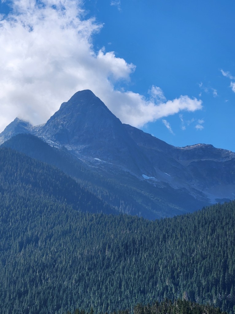
North Cascades is really a backpacker’s (or a climber’s/mountaineer’s) park. There’s no entry fee, and only a few spots accessible by road. Most of the park is very steep, rocky, glaciated peaks with narrow valleys, and if you’re not willing to get out into the backcountry, your options are limited. Particularly on days when the clouds were hanging low… though we were starting to see signs that the fog may burn off.
Though we could see evidence of the mountains, in the form of steep rocky cliffs pretty much everywhere, disappearing quickly into the clouds, the views UP just weren’t happening. So we decided our first stop(s) would be views down. Accordingly we kept driving up the Skagit River through Newhalem (a company town for Seattle City Light), and past the hydro plant at the Gorge Dam to a parking area with a short trail overlooking Gorge Lake.

Blue! So blue. The lakes here – even though they’re manmade, created by the hydroelectric dams – are absolutely gorgeous. They’re filled with a fine suspension of glacial silt coming off the surrounding mountains, and that causes the lakes to shine with a stunning turquoise color. I guess it’s a similar effect to having very white sand in Caribbean waters creating that same color near islands. It certainly felt very tropical, or it would have had it not been for the steep, conifer-covered mountains surrounding the lake. The sun was just beginning to poke through the clouds, so we were starting to get enough light to actually capture the color.

Most people were pulling over here and just walking out and back to the view of the lake, but there is a short, level loop here around a little high point. So we took the opportunity to stretch our legs a but and get the blood pumping. The view in the gorge, and of the dam, wasn’t as good as we’d hoped, but the walk in the woods was nice. Very green, very lush, and it was hard to believe there were glaciers on peaks very close by.

Having completed the loop, we walked down the road and over a steel walkway on the bridge across a gorge with views of thin Gorge Creek Falls. The falls themselves were nothing more than a thin cascade (though still pretty), but what captured our attention was the see-through bridge deck and the loooooong drop underneath our feet.

It became clear at this point that the low foggy weather was indeed just a temporary anomaly. Blue skies were starting to push through the clouds and the nearby peaks were starting to become visible. It was going to be another beautiful day after all!

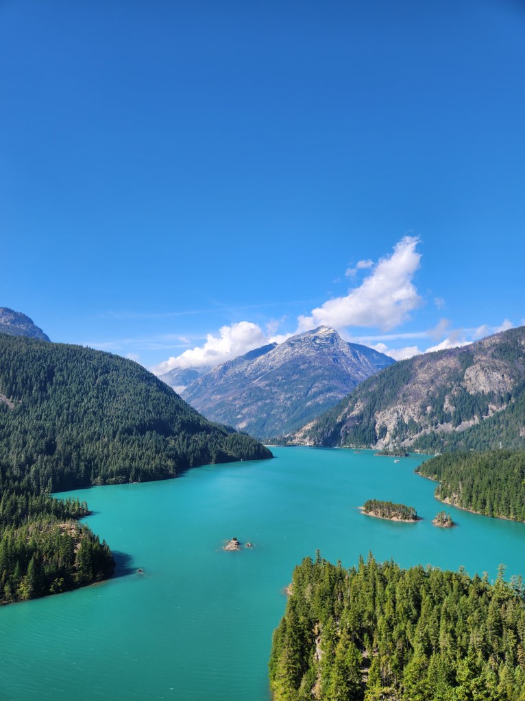
We continued on into the Cascades, headed to Diablo Lake. This was one of the spots we’d seen pictures of in our early destination planning. It seemed impossible that the lake could be as Caribbean turquoise as pictures made it out to be, but now that we’d seen Gorge Lake we were more optimistic that it would be that striking for real. With the sun now coming out, it seemed likely we’d get a good show, and Diablo Lake did not disappoint.

The popular viewpoint is situated up on a bluff a couple hundred feet above the lake, with views back toward the dam and the Gorge. Glaciated mountains surround the lake, which is indeed a deep turquoise. Not only had the clouds broken, quite quickly, but the wind had picked up, and we could see whitecaps forming on the lake. We could also spot a few lakeside, paddle-in campsites down there, which evoked thoughts of future adventures. Back at the Visitor’s Center, we had actually discussed the feasibility of renting a canoe and paddling nearby Ross Lake, but now that the wind was blowing the temperatures were dropping, and we decided that might not be a great idea, at least not today.
From here we continued on across the spine of the Cascades and back to the southeast. I’m going to skip this a bit, and focus on what we saw there NEXT time, and instead circle back to our RETURN journey where we stopped again at Diablo Lake, this time under more dramatic, cloudy skies. A weather front was finally moving in from the west, but it would still likely be a day or two before any rain really happened. Still, the clouds gave the lake a different air, in addition to making some of the nearby mountains easier to view, now that we weren’t staring at the sun.

We also made a short stop at the rocky beach where the main road crosses the lake between the Colonial Creek Campgrounds. The parking lot here is labelled Thunder Knob, so I’m going to call the collection of stones here Thunder Knob Beach, though I’m not at all certain that’s what it’s called. There is a nice view northward up the lake toward Sourdough Mountain, and it’s noticeable that from this angle, at lake level, the bright turquoise color of the lake isn’t nearly as apparent. The reflections and refractions necessary to have glacial silt turn an entire lake also require an angle that’s looking down into the lake from some amount of elevation above it.

You’ll note I skipped a bit of our journey to return back to Diablo. This is a bit of an awkward break, but I didn’t really want to include Diablo, Part 2 in the discussion of the rest of our day. Instead, next time, I’ll talk about the eastern most extent of our journey at the stunning Washington Pass and our adventures outside the National Park, traversing the Mountain Loop Highway and exploring the Big Four Mountain Ice Caves inside Mt. Baker-Snoqualmie National Forest.

Get Out There

Glad to see the clouds and mist cleared and you got to enjoy blue skies and sunshine. The colour of the water at Diablo Lake is gorgeous. We haven’t visited North Cascades yet, but it’s on the list.
LikeLiked by 1 person
Ours was only a quick trip through, but it was surprisingly beautiful. To really get into it I think you have to be prepared to get out into the backcountry for a while.
LikeLike
We spent several hours kayaking on Diablo Lake when we visited North Cascades last year. Truly beautiful.
LikeLiked by 1 person
I can imagine. We were sorely tempted to find a boat somewhere!
LikeLike
Quite beautiful. It was also fun hanging out with the ducks and geese.
LikeLike