
The morning of Day 4 (Tuesday) dawned cool and foggy. It had gotten down to about 45 deg the night before, enough to prompt an extra layer in Bones to stay warm. The fog had settled into the little creek valley and plunged our campsite into low visibility mist. We’d had no more visitation or noises from coyotes, or anybody else, during the night, and we were eager to get an early start and get up to the Paradise area of Mt. Rainier before the crowds showed up. So we made some coffee, had a bite of fruit, and got on the road.

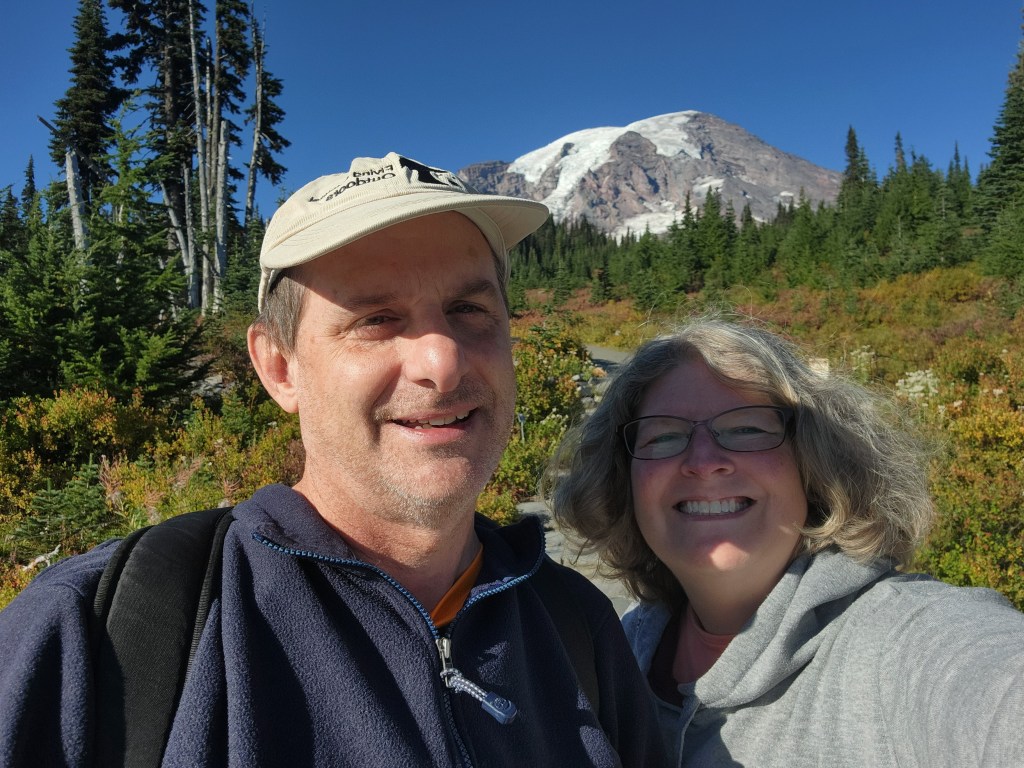
Having camped only about twenty miles away, our drive into Mt. Rainier National Park was a quick one, but the fog lingered. Fortunately, we were climbing, and soon we broke out above the clouds (they would continue to break up through the morning) and we were blessed with views of Mt. Rainier’s summit looming above us as we pulled into the Panorama area.

My wife had some lingering concerns about hiking here – partly because stories from friends had recounted tough climbs and hard weather, but also because of the thinner air at high elevations. Well, the weather was perfect, and it turns out that the Paradise Visitor’s Center is at only 5,400 feet, just a little higher than Hurricane Ridge. So, no problem! Let’s get walking.
Myrtle Falls
Myrtle Falls is not only a short relatively easy hike from the Visitor’s Center, it is the beginning of the larger Skyline Loop that leads up to within spitting distance of Rainier’s glaciers. So whether you’re interested in a short walk or a long one, Myrtle Falls is probably on your way.

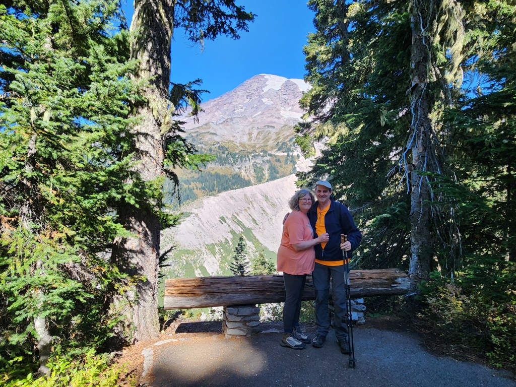
The trail starts right behind the Visitor’s Center, where a stairway with an inspirational John Muir quote leads directly toward Rainier, framing the summit perfectly. When we were there, the main trail was blocked to support some digging and repair of a drainage system behind the lodge, so we had to deviate uphill and take a slightly steeper route for a bit. The payoff for this was an unexpected encounter with a bold ptarmigan that didn’t seem to mind people. It was foraging around in tall grass and was impossible to get a good photo of, but we watched and tried anyway. It’s little hoot/cluck noises were entertaining, and it “talked” continuously while pushing through the grass looking for food.

The deviation left us on the paved Waterfall Trail, going back down a little bit before re-engaging the Skyline Trail and climbing back up to Myrtle Falls. This whole section of the trail is paved, and while it’s not steep, flat-landers (like us) will feel the steady 200-foot climb. The bright side is a continuous view of Mt. Rainier’s summit, dead ahead, Paradise Valley to the right, and (at least in late September) beautiful autumn reds and yellows among the blueberries and other shrubs covering the alpine meadows.

When the paved trail ends, there are several benches available to take a break. Straight ahead, the Skyline Trail continues onto a bridge across Edith Creek, where there are gorgeous views of the creek tumbling down off Rainier. To the right, a short side trail leads steeply down to a view of Myrtle Falls – Edith Creek tumbling off a 60-foot ledge. From this viewpoint, the falls, bridge, and Rainier summit are excellently framed by the trees. Beautiful.


While chatting with some other visitors at the benches atop the falls, a group of Canada jays flew in and hopped around looking for handouts. At least, they behaved (obviously) as if they expected handouts. At the same time, a chipmunk jumped out of the blueberries and ran up and down the path, perhaps a little more warily than the birds, but still clearly looking for handouts. They didn’t get any, which is good – don’t feed the wildlife!


Myrtle Falls Trail Key Parameters:
Length – 1.2 miles round trip
Ascent – +/- 200 feet
Trailhead – 46.78651, -121.73640


Nisqually Vista
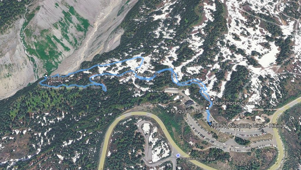
Our second trip required a short drive back downhill to the lower Paradise lot. From here, the Nisqually Vista Trail passes over a shoulder of the mountain to an overlook with a clear view of the arcing Nisqually Glacier, covering most of the south side of Rainier.
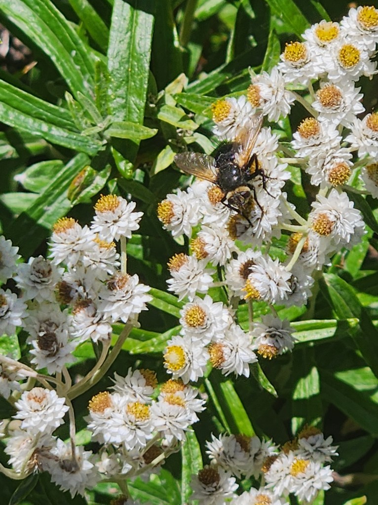
Along the way, we passed from alpine meadows into montane evergreen forests containing hemlock, spruce and fir. Wildflowers such as cascade aster and pearl everlasting (some open, some resembling bushes full of little spherical eyeballs) grew along the fringes of the meadow areas.

The trail splits into a loop, and we took the left fork to walk clockwise. The trail here drops down off the southern side of the slight ridgeline, and in doing so the sound of rushing water – very noticeable up to this point – vanished, the source obviously blocked by the land. Instead, we heard the birds, including a few songbirds and a croaking raven flying overhead. After a half-mile or so, the trail arcs back up and to the right, and the sound of water returns suddenly as the trail opens up to the lowest viewpoint facing the glacier.
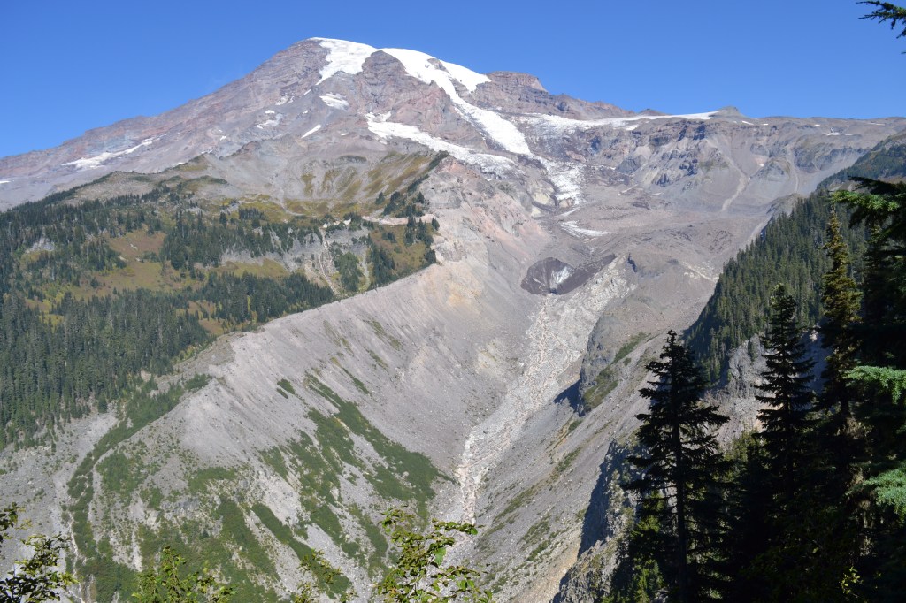
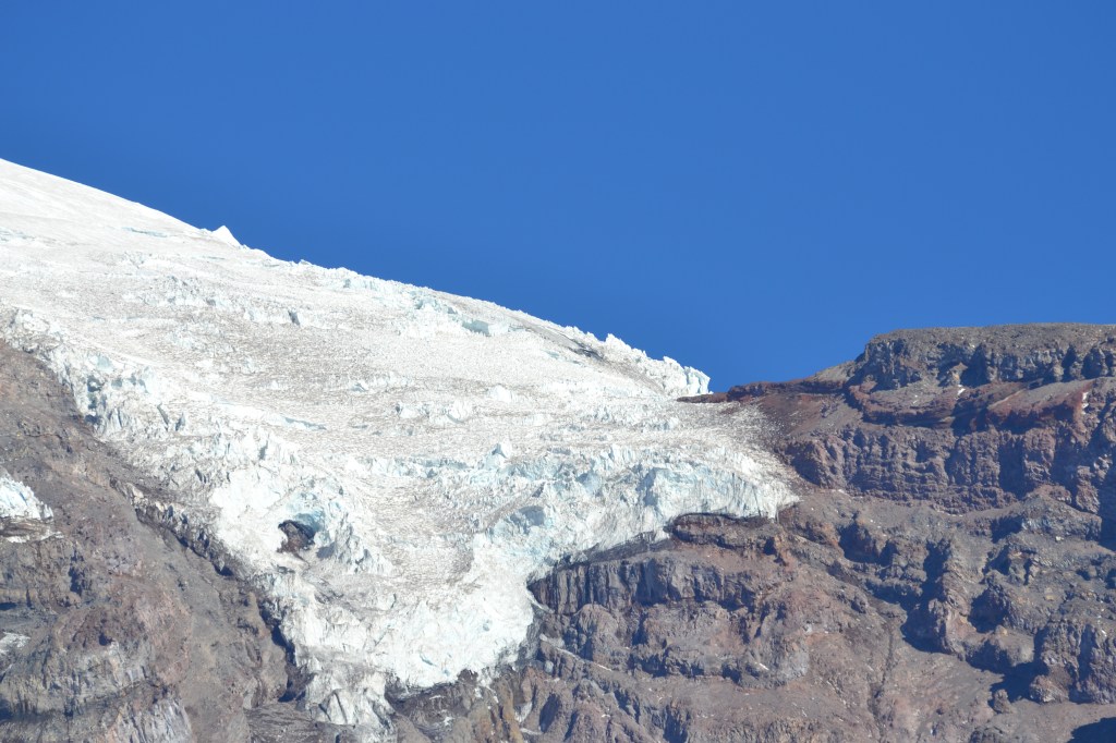
Again, we were here in late September, probably at the point where snow cover is at a minimum. Still, the glacier was impressive. About halfway down the mountain (the summit is about 9000 feet above you at this point), the glacier turns brown, covered with dust and dirt, so it takes some close attention to follow the arc of the glacier all the way down to its toe. That portion of the glacier is obvious though – a dark cone marks the place where the ice stops, and a tunnel at the bottom of the glacier is disgorging the Nisqually River, augmented by a small waterfall pouring off the top of the glacier into the main channel.

This river is the color of chocolate milk, and is the source of the noise that is audible on most of this path. The meltwater pours down the valley, and in some places cascades dramatically over sudden drops, creating the noise of multiple waterfalls all the way down. The valley is a clean, curved “U” shape in profile, giving evidence that at one point (how long ago, I wonder?) the entire valley was filled with, and carved by, the glacier, which has since receded far up the valley.
It takes a bit of watching and some close observation, but as you stand here observing Nisqually, details emerge. For example: You notice a separate waterfall pouring off the left side of the valley to join the river fall below (Nisqually Valley Falls). You notice crevasses, large fractures, in the “clean” white icy part of the glacier high up the mountain. You realize that the summit is still about four and a half miles away from this point, as the crow flies, and the scale of this mountain hits home.
Leaving this viewpoint, the trail continues to the right, back up along the ridgeline and past several other viewpoints on its way back to the lower Paradise lot.
Nisqually Vista Trail Key Parameters:
Length – 1.2 miles, lollipop
Ascent – +/- 150 feet
Trailhead – 46.78505, -121.74161

In my next post, I’ll get into the afternoon of Day 4 – a few more stops on Rainier before heading out Stevens Canyon, past the actively burning Wildcat Fire and to our campsite in the Naches River valley.
Get Out There

You got lucky with some wonderful weather here. And got some great photos as a result! The fog you encountered stayed low but I recall looking out from Camp Muir (10,000 feet) over a sea of clouds that lapped at my feet. It was an amazingly unforgettable sight.
LikeLiked by 1 person
We really did get lucky. And I can only imagine being up at Camp Muir. The Wonderland is one of my bucket list trips, but getting up above 10K and up to the glaciers sounds really enticing too!
LikeLike
If you’re real motivated, you can visit Camp Muir as a (long) day hike. I don’t know what the current permit situation is, but back then (if you weren’t trying to climb Rainier), you could do an overnight backpack to Camp Muir without one.
LikeLiked by 1 person
Interesting… Will have to investigate that! Thanks!
LikeLike
Very interesting post. I was surprised by how dark the glacier appeared near its toe. Forest fire ash is reportedly darkening some glaciers and accelerating their melt – as the darker surface absorbs more sunlight. The exposed moraine clearly shows where the glacier once reached. Many of the mountains in this region also have retreating glaciers. I often think that, in geological terms, it wouldn’t take long for them to return. It’s always fascinating to look at a mountain or valley and imagine it as it once was covered in ice. Sounds like a great trip!
LikeLiked by 1 person
I hadn’t thought of wildfire smoke, but I’m sure that contributes to the darkening of the ice. Given the color, I imagine a lot of it is just wind-blown dust from the mountain itself, probably laid down more or less continuously and coming out in the chocolate-milk meltwater that makes up the Nisqually River.
This whole thing made me do some digging, and I found the photo below from 1922 (Marvin Boland, public domain) showing the glacier from pretty much the same location. It had some periods of growth in the 50s through the 70s, but overall has retreated over 2 miles in the last 100 years.
LikeLike
We would have loved to have visited Mount Rainier when we went to Washington a couple of years ago, but we went in April and much of the park was still closed because of the snow. Your pictures are stunning.
LikeLiked by 1 person
We really did get lucky to wind up here on such a beautiful clear day. The landscape makes amateur shots look good! =)
LikeLiked by 1 person