
What does this little snippet of a map mean to you?
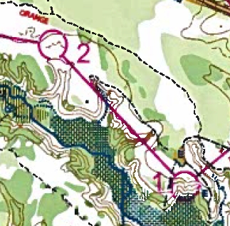 If you’re familiar with topographical maps, it may be relatively easy to see a creek valley (blue line) with a wide bottom and intermittent flooding (blue shading, also known as a marsh). Brown lines show elevation contours that indicate changes in elevation, and close stacking indicates steeper slopes. Knowing this, you can detect steep drainage valleys that come off a relatively flat plateau. You might also notice a trail (dashed black line).
But the red line is what matters. In a competitive orienteering race where you might be given a map like this, the straight line between the targets, called “controls” cuts through steep gullies – and the shortest (quickest) course is definitely NOT a straight line.
 Clues such as this also give indications as to where you might find the one-foot white and orange cube marking the control – in this case, the 2nd control is number 125, located on the west side of a creek inlet, north of a shallow depression.
Now, string these together into a course of (in this particular example) 10 controls covering 4.2 km of straight line distance, and race to find them, in order, as quickly as you can.
This is competitive orienteering, and it is a challenging and fun way to test your navigation skills and your ability to read terrain. I ran a course recently at Patuxent River Park, MD, at an event held by the Quantico Orienteering Club, completing the course in one hour, 34 minutes. Good enough to finish right in the middle of the pack, number 16 of 28.
It was not without trials and tribulations – check out my video on YouTube. A little longer than some, but hopefully it captures the feel and the constant awareness and decision making it takes to launch off trail with confidence you will return! A LOT of fun, I recommend you give this a try… it’s entertaining, AND it hones some very useful outdoor skills!
Get Out There
Troy
flying-squirrel.org
