
Last Wednesday night, on Aug 27, NASA successfully launched The TOMEX+ (Turbulent Oxygen Mixing Experiment Plus) mission from the Wallops Island launch complex on the Eastern Shore of Virginia, and I got to watch it from home!
Building on the success of the original TOMEX mission launched in 2000, TOMEX+ used a trio of sounding rockets to peer into one of Earth’s most mysterious atmospheric regions, the mesopause. The target was a narrow band of atmosphere spanning 53 to 65 miles (85 to 105 kilometers) above Earth’s surface, a region that’s too high for weather balloons to reach and too low for satellites to effectively study. This mesopause region is the coldest layer of Earth’s atmosphere and the birthplace of noctilucent clouds, those ethereal, electric-blue formations that sometimes grace summer skies. This region is also home to a thin layer of atomic sodium created by the constant rain of tiny meteors, and this layer is key to the attempt by TOMEX+ to measure the structure of the menopause in three dimensions.

Wallops is close enough to home that I can see launches from my front yard (well, the cul-de-sac in front of the house). Back in 2013, the LADEE lunar explorer mission was particularly impressive, and International Space Station resupply missions are also fun (particularly since you can see the ISS pass over shortly before the launch).
Though they aren’t as big, sounding rockets are interesting too! They’re too small to see the rocket exhaust plume from this distance (I live just west of the Chesapeake), but the missions themselves are typically designed to interact in a visual way with the upper atmosphere, so we’re treated to an impressive light show even if we can’t see the launch itself.
The TOMEX+ launch window opened on Monday the 25th, but clouds and storms around the observation sites scrubbed the mission after about 3 hours of waiting. On Tuesday the 26th, same result. But Wed, the 27th was absolutely crystal clear up and down the coast!
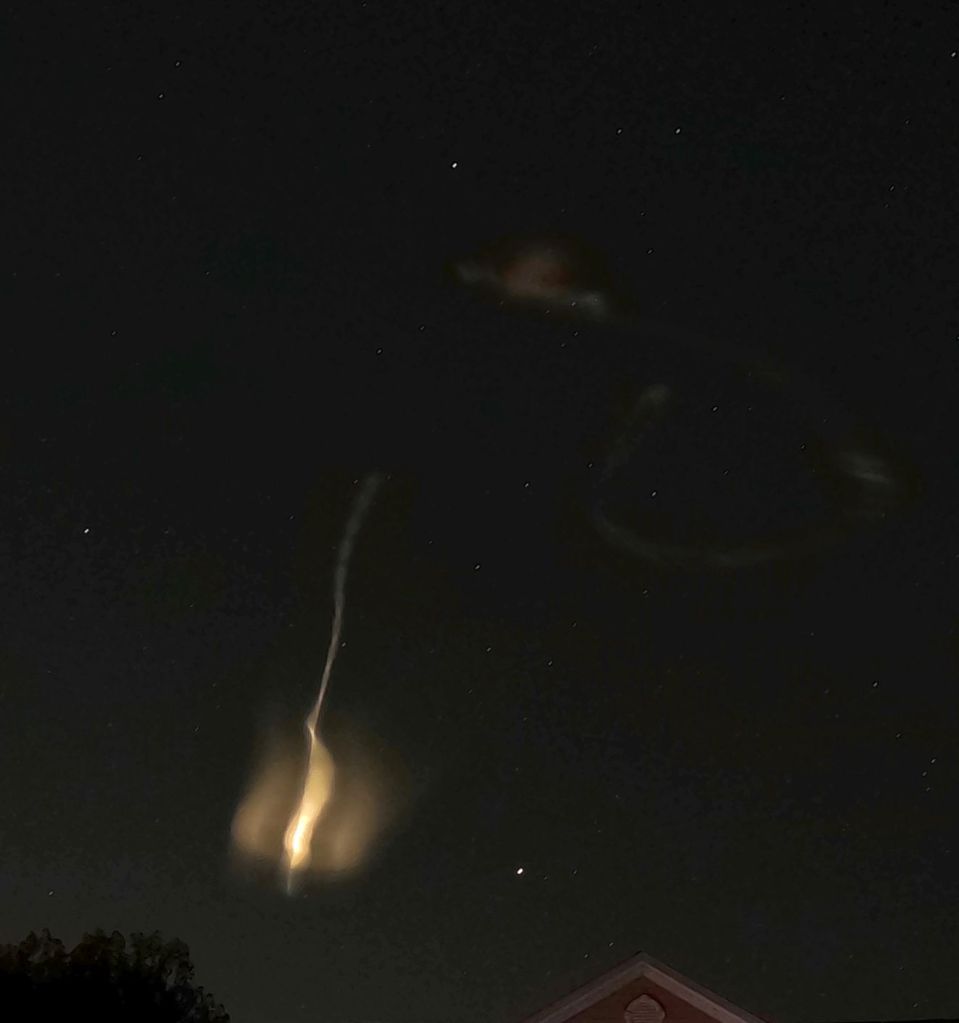
Just after 10:30 pm, two rockets launched within a minute of each other, releasing bright white vapor tracers into the upper atmosphere. These clouds are designed to provide visual evidence of wind patterns and atmospheric motion. We were listening to the launch feed over the internet, and saw the vapor tracers emerge about two minutes after the countdown hit zero. From our perspective, the first rocket appeared to release a tracer on its way up, and the second, a few minutes later, reduced tracers on the way back down.
The images below are taken with a GoPro in NightLapse mode, wherein the exposure lasts 30 seconds. The increasing curvature of the path shows clearly (when correlated to altitude) the differences in wind velocity along the rocket’s path.


About five minutes later, a third rocket carrying a specialized lidar (light detection and ranging) system was launched. This rocket’s laser was precisely tuned to excite the sodium atoms floating in the mesopause. By analyzing how this light bounces back, scientists can measure atmospheric density changes and track motion over time. Sadly, none of the third rocket’s activity was visible from our vantage point, but the vapor tracers from the first two was plenty neat!
I don’t know how successful the mission was. In theory, the science team was able to measure a turbulent part of the atmosphere where different atmospheric layers mix and interact in complex ways. Understanding these processes will help scientists better predict high-altitude cloud formation, understand satellite drag effects, and even inform our knowledge of atmospheric processes on other planets.
I’m glad to have been able to watch it happen!

Get Out There!
