
February 9-10, 2025 — Most people, when you mention Hawai’i, think of a lush tropical paradise and beautiful beaches. But these islands wouldn’t be what they are without the volcanism that created them. On the “newer” islands in particular, Hawai’i has some significant volcanoes that reach above 10,000 feet elevation and create their own weather systems, distinctly different from the tropical lowlands. On the Big Island, these volcanoes are still very much active, but Maui also has a sleeping giant, Haleakala, the House of the Rising Sun, at 10,023 feet.
Keeping with its moniker, Haleakala is a very popular place to view the sunrise. Haleakala is a sacred mountain, the site of ceremony and astronomical studies by native Hawai’ians for centuries. Watching the sun rise over the summit crater is a beautiful, and spiritual experience. Another popular activity is biking DOWN the mountain, starting just outside the Haleakala National Park boundary at about 6,700 feet.
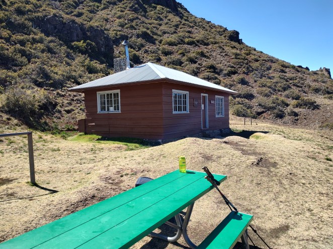
Haleakala also contains ten backcountry tent spots (five each at Paliku and Holua) and three cabins (Paliku, Holua and Kapalaoa). At the time of this writing, overnight reservations are available through recreation.gov for $20/night at a tent site, or $70/night to rent a cabin. I was able to grab Holua Site #2 on the evening of Super Bowl Sunday – a perfect target because not only do I care very little about the big game, it was also a convenient chance to steal the family’s rental car on a day it would not be missed.
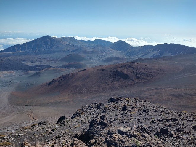
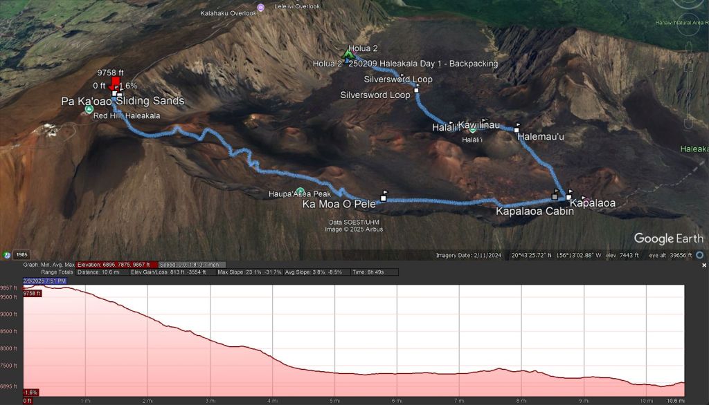
As National Parks go, Haleakala is small, and its limited trail system is shaped roughly like a 10-mile long, skinny triangle that runs from the summit and Halemau’u Trailhead in the west to Paliku campground and cabin in the east. In between, several north-south trails cut across the triangle to give close encounters with the cinder cones that dot the crater floor. From Paliku, the Kaupo Trail also leads south and out of the park through the Kaupo Gap. This provides a very strenuous way to enter the crater – a 7,000 foot climb directly up the mountain from sea level.
Most backpackers (at least it appeared to me through some discussion with those I encountered) seem to opt for a 2-night trip totaling about 20 miles: Start at the summit, descend via Sliding Sands Trail out to Paliku for night 1. On day 2 cut back across the crater via Halemau’u trail to Holua for night 2. Then exit via Halemau’u Trailhead.
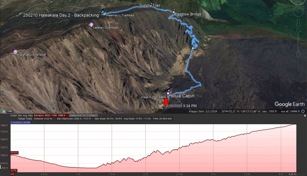
I did a one-night variation of this itinerary – Start at the summit, descend via Sliding Sands to the Kapalaoa Cabin for lunch, then cut back across via Kapalaoa Trail to intersect Halemau’u and stay at Holua for one night, then out via Halemau’u. This route is just shy of 14.5 miles (My trip was a little longer because I elected to go up and back down White Hill – Pa Ka’oao – before starting the descent).
Also popular is the dayhike version. At 11.2 miles, the shortest route between the summit and Halemau’u will take you into the crater and across the western-most cinder cones before climbing back out. Shorter routes are certainly available from either trailhead as out-and-back routes.
Note that Halemau’u is 2,000 feet lower than the Sliding Sands trailhead. So all these routes represent a net descent, though there’s some significant up and down regardless.

Because the Sliding Sands to Halemau’u routes are so popular, the Park has designated a hiker pickup zone for hitch-hike shuttles to the summit. Park at Halemau’u, take the spur trail across the road to the wide shoulder where signs encourage other visitors to pick you up. I’ll admit I was anxious about how well this would work, but when I walked to the pickup area there was a visitor there who had just pulled over to take pictures, and he readily agreed to give me a ride up. Many thanks to Dan, from British Columbia! (I later saw Dan again in the crater – he had committed to the 11-mile dayhike loop and hoped he’d have as much luck with a ride back to the summit as I did).
My Trip – Day 1
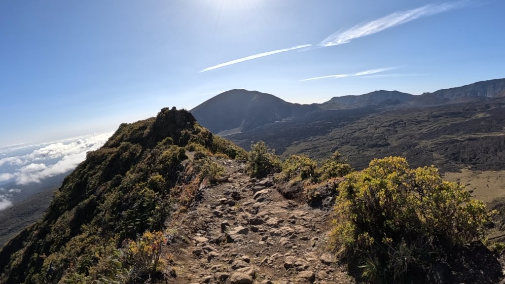
As I mentioned, Haleakala is a very popular sunrise destination. So much so that timed entry reservations are needed between 3 and 7 am. Arrive after that window, though, and no reservations are required. I entered the park at about 9am ($30/vehicle, good for 3 days) and found plenty of open parking at Halemau’u. I got a quick ride with Dan, as I described, and then because I’m a glutton for punishment I hiked up White Hill aka Pa Ka’oao (9,862 feet) for good starting views of the crater. This is also a good place to view the true summit on Red Hill (10,023 feet – I had tagged the summit a day earlier with the family), and the astronomical observatory complex.
The summit area also has a small gift shop and a restroom building. This is a good opportunity to grab any last-minute souvenirs or to ask a ranger about water availability in the crater.
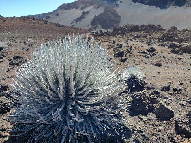
After that quick stop, it’s down, down, down. The Sliding Sands – aka Keonehe’ehe’e – Trail drops almost 3,000 feet via long, wide switchbacks before flattening out at about 7,200 feet. Along the way, you transition between feeling tiny in a wide open space to moments of closed walking between giant chunks of lava. You’ll pass by groups of endemic (and endangered) ‘ahinahina, the famed silversword that grows nowhere else in the world. You’ll also see green kapuoa shrubs that also grow nowhere else.

The climate here is arid. It’s essentially a desert, though high winds and elevation can make it feel cool, you’re also subjected to high-intensity tropical sun, and there’s no shade to be found. Sun protection is essential, and the risk of dehydration is real. I carried 3 liters with me, and (thanks to availability of water this time of year) consumed about 6 liters over the course of my trip. Of course my dinner plan was more water-heavy than it had to be, but don’t skimp on water!
In certain areas, you can see where occasional rainfall and/or the ability of the high ridges to capture and collect moisture from passing clouds has created an environment where shrubs and grasses can grow – not coincidentally, these areas are where you’ll find campsites – but outside that, toward the center of the crater, you might as well be walking on Mars.
I passed up the option for the shorter loop and continued to Kapalaoa cabin for three reasons. One, it had a picnic table and would be a great spot for a lunch break. Two, it would provide what I thought would be a more interesting route back across the crater through the prominent red cinder cones (and past one intriguingly named the Chicken of Pele – Ka Moa O Pele). Three, I had the time and inclination to lay down more miles.
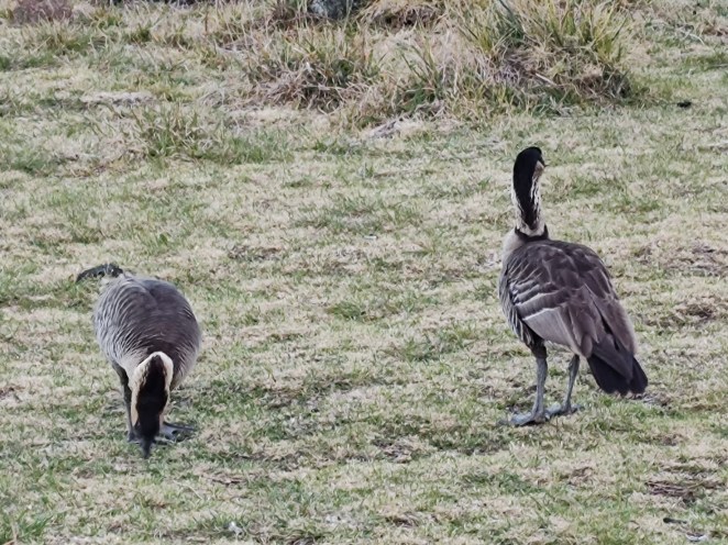
Kapalaoa also turned out to be the place I’d see my first nene (Hawaiian Goose, and state bird of Hawaii) of the trip. There was a pair sitting under the picnic table enjoying the shade. They moved away a short distance as I approached and claimed a spot on the end of the bench to sit and set up my stove, but before long they decided I wasn’t a threat and returned to sit under the table no more than five feet from me. Nene are about three-quarters the size of a Canada goose, or about a duck-and-a-half. They have a distinct black stripe pattern on their white necks, and a more polite, higher-pitched honk than the geese I’m accustomed to. They also mate for life, so all the nene I saw were in pairs. The ones I encountered generally kept their distance, but were not terribly afraid of humans. I’d wind up seeing seven pairs of adults and two goslings over the course of this trip.

After lunch – grilled monterey jack and of course, Spam (the hot and spicy variety) on a bagel made of Hawai’ian sweet roll – I set off across the lava plain and around the cinder cones. Terrain ranged from sandy to rocky, weaving in and out of rough, a’a lava fields. The colors were amazing, from black to deep red with shades of yellow and green mixed in, reflecting the different chemical compositions of the ejected material.
The sun was pretty relentless out here, and walking across a field of black rock generated the temperature environment you could anticipate on an enormous parking lot. The reflected heat off the sand and the direct sun made the air near the ground reach 93 deg F, according to my thermometer. It was hot enough I started to wish for the summit winds to return. Weaving around the cinder cones yielded close up views of mini-volcanoes and other oddities, like Kawilinau, a 65-foot deep hole surrounded by volcanic ejecta.

Leaving the cones, with about 2 miles to go, the trail rejoins the “short” dayhike route and crosses one of the more recent (900 years ago) lava fields, and the trail picks its way through rugged, rocky terrain. With about a mile to go, the trail splits in two to form the Silversword Loop. I elected to take the northern (right) path, and while there were silverswords here, there weren’t more than I’d already seen on Sliding Sands. If you came down from Halemau’u Trailhead, though, this would probably be your first chance to see silverswords.
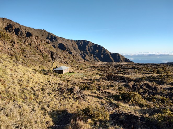
Eventually, the terrain turned grassy again, and I arrived at the Holua Cabin. The campground is south (to the left as you arrive), up a short but steep hill. One person I encountered at the cabin described the climb as a “vortex of pain”, where you can really feel the effects of the high elevation. I had to agree. The sites at Holua are close, but well hidden from each other by large shrubs of pukiawe. Site 2 (mine) appeared to be the most secluded, by dumb luck.

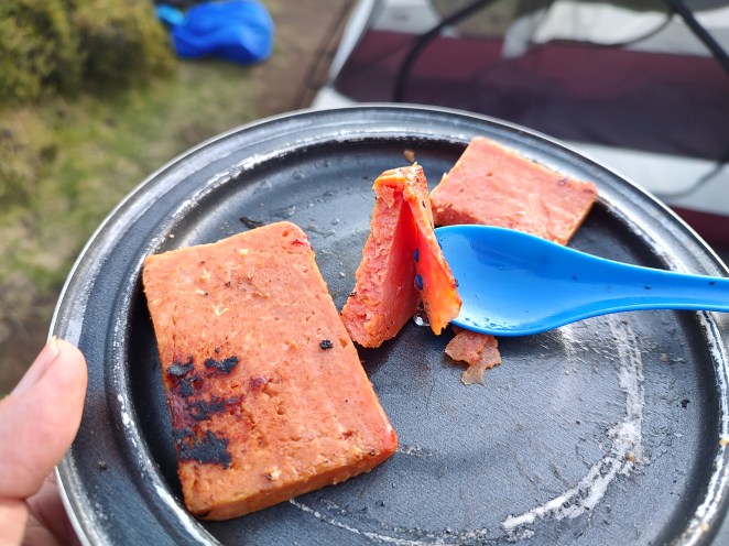
I was pretty tired after a 10.6-mile day at elevations I’m not used to, so it was a slow night. I made an experimental Hawai’i/Asian shepherd’s pie – Teriyaki Spam (of course) in garlic mashed potato with dried nori, shiitake mushroom and daikon radish. A dash of soy sauce made it better. A good experiment!

After meeting the local nene (another 2 pair plus one gosling at the campground, and a pair at the cabin), I turned in. In the middle of the night I got up to check the stars, but a waxing gibbous moon washed out the sky. Still beautiful. I heard some nearby nene as I exited the tent, and found a pair blocking my way to the outhouse. I was patient enough to let them move on, but then when I got back, I found the pair in my campsite, sitting right in front of my tent. Again, they moved on, this time walking straight over a lava pile. Tough birds!
Day 2
I woke up early, to catch sunrise. It seemed appropriate for the House of the Rising Sun. After seeing temps in the 90s during midday, my thermometer recorded a low of 49 degrees F overnight in the tent, but I stayed cozy. I packed up, ate the remaining Spam and bagel from the previous day’s lunch, and was out before 7:30. I was able to make a quick stop at the cabin and got to peek inside (courtesy of its sole occupant, who was up watching the sunrise herself), and then made my way down into Ko’olau Gap, one of two exit points out of the summit crater, and the place where lava flows and erosion had dumped material down toward the northern part of the island. A persistent cloud bank had hovered at the brink of the gap for my entire journey, and I had to keep reminding myself that there was another 6,000 feet of air UNDER those clouds, down toward the Pacific.
The climb up the western ridge along the edge of Ko’olau was impressive in and of itself. I started from the low point of the entire journey, at about 6,600 feet, to climb 1,400 feet over about 3 miles. The trail here was cut in the 1930s, by the Civilian Conservation Corps, and formed a narrow path between a cliff wall on one side and a near-vertical drop on the other. The exposure was dramatic, particularly walking around the edge of the ridge line onto the north-facing side, toward the ocean, where there was a dramatic increase in vegetation. It was clear the mountain could catch the moisture from clouds on this side.
A little more than a mile from the Halemau’u Trailhead, the path crossed what I’ve heard is called the Rainbow Bridge – a short, narrow stretch of trail across the top of the world with 1,000 foot drop into the crater on one side, and about 3,000 into the jungle on the other, eventually going down over 7,000 feet to the ocean. I was glad the wind was not blowing across the ridgetop, or I might have feared the height a little more than I did. As it was, I got to just enjoy the view!
After the bridge, the trail moves away from the crater for good, and climbs up the outside of the volcano to the trailhead. The entire Halemau’u trail is constructed in a way that is not steep, but it is relentless. The occasional rock “steps” created for water-diversion are frustratingly high, and are challenging to step up or down, and the tread itself is rocky and uneven. I made the entire climb without any stops, but my legs were feeling the burn as I arrived back at the trailhead, to be greeted by another pair of nene.
Overall, Haleakala strikes me as a place of contrasts. Desolation on a tropical island, cold winds at the summit and blistering heat in the crater, desert conditions inside, tropical vegetation outside. It’s easy to see why this is such an important, spiritual place, and I highly recommend the trip if you get the chance!
Get Out There!
Key Parameters:
     Length - 14.8 miles (Shortest day-trip approximating my route is 11.2 miles)
     Ascent - 2,213 feet; Descent - 4,054 feet
     Water - Seasonally available at Holua and Paliku, via cistern and gravity feed to sources at campgrounds and cabins. Generally water is available during the winter months, and dry during the summer. Check with a ranger before you commit! The crater interior is essentially desert hiking. (Treat all water sources.)
     Camping - Five individual tent sites each at Paliku and Holua.
     Other Considerations - Exposure! Haleakala can present significant temperature differences between day and night. There is little to no shade, and an intense tropical sun at high elevation. Trail conditions include hard-pack dirt, soft sand, rough A'a lava, and loose rolling lava rock.
     Hitch-hiking - Permitted/encouraged in the park. Take a spur trail from Halemau'u Trailhead across the road to a designated hiker pickup area for a ride to the summit.
     Trailhead - Halemau'u 20.75250, -156.22854; Summit Parking / Sliding Sands 20.71450, -156.25073

The Hawaiian Islands purchase 8 million cans of SPAM a year – more than any other place where we ship (or produce) SPAM. Good stuff – made in Austin, Minnesota!
LikeLiked by 1 person
That’s why I committed to two cans of the stuff! Spam is such a part of the zeitgeist on the islands I had to build some backpacking recipes around it.
You have some insider knowledge on Spam production, or just a fan, yourself?
LikeLike
We went down to visit the SPAM museum a few weeks ago. Good history on how SPAM came to Austin, the production process, and where it’s all shipped. Also bought a few cans of the 14 different flavors.
LikeLiked by 1 person
That’s a lot of Spam! I’m going to have to look up the 14 flavors, because that seems like some have GOT to be unnecessary.
(As an aside, it is very tempting to look at the comments on this topic and hit the “Mark as Spam” button!)
LikeLike
Great coverage of your trip! I can see the challenge. Grin. Mainly down and up. Amused by the spam. Peggy and I discovered that some of the best restaurants in Hilo had it on their menu. And impressed with your meals, overall. Creative. It’s been fun reading your posts considering Peggy and I were wandering the Big Island at the same time, although at 81 my hikes weren’t quite as ambitious. Grin. We got some fun Nene shots as well. Lots of the roads had “Nene Crossing” signs on them. Hawaiians take their care seriously. I’ll continue to do Hawaii posts for the next few weeks while I alternate them with the Danube River trip we took in the fall. Now Peggy and I are busy getting ready for our four month trip to the Southwest we will start mid-March.
LikeLiked by 1 person
Yeah it was pretty neat that we were in Hawai’i at the same time. I’ve been out there several times but this is the first time I saw nene. The quantity in Maui seemed to make up for my previous failures!
Hard to keep up with you globetrotters. Still (for now) enjoying the Danube trip, but looking forward to hearing about Hawai’i and your upcoming southwest trip!
LikeLike
We weren’t able to get tickets to watch the sunrise in Haleakala when we were in Maui a few years ago. And we only hiked a portion of the Sliding Sands. The landscape looks otherworldly. Glad to hear you were able to get a ride to the starting point of your hike. Sounds like quite the adventure.
LikeLiked by 1 person
Again, I appreciate your post from a few years back! It triggered me to take a closer look at what I could do with this trip. I was very grateful the rest of the family let me run away for a bit and do this!
LikeLiked by 1 person