Oct 27-28, 2023 — A beautiful 12 mile loop in the Great North Mountain area of the George Washington National Forest, along the VA/WV border. The embedded video tracks an overnight trip in October, slightly past the peak of fall color in the Allegheny Mountains. I had numerous and varied wildlife sightings and solitude during my one night out.
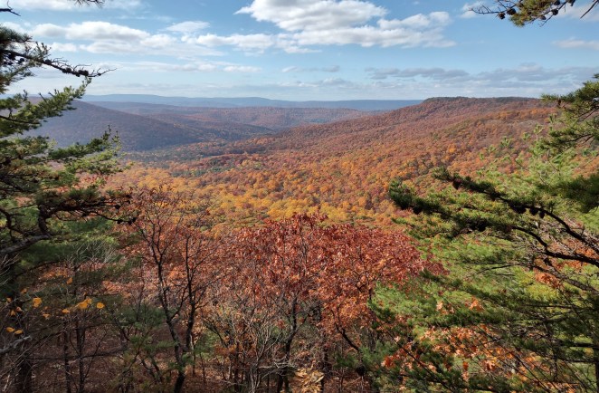
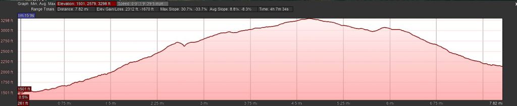
The route starts south of Wardensville, WV at the Pond Run Trailhead (39.01588, -78.60535) and tracks the Tuscarora Trail south up Pond Run, with multiple creek crossings, to reach a saddle atop the ridge of Halfmoon Mountain. There are numerous campsites here, and a clifftop view just to the west with beautiful views through the Halfmoon Run valley .
From here the trail turns east to track up the slope of Sugar Knob. On my circuit, I added a quick out and back to the summit of Mill Mountain (3,301 feet, no views), the high point of the trip. The trail continues east, passing south of the peak of Sugar Knob and passing side trails to Little Stoney Creek and to Little Schloss, both excellent trips in their own right.

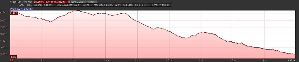
I turned north to leave the Tuscarora and descended into Racer Camp Hollow, proceeded just far enough to access a flat camping spot near running water (though an extra tenth of a mile would have resulted in finding a nice pre-established campsite).
The next morning, I continued north through Racer Camp Hollow, taking a left on Old Mail Path and eventually reaching Waites Run Road to return to the trailhead.
Key Parameters:
     Length - 12.75 miles (incl. out and back to Mill Mountain)
     Ascent - 2,106 feet
     Water - Abundant along Pond Run and in Racer Camp Hollow. Piped Spring 150 yards south on Little Stoney Creek Trail, near the Sugar Knob Cabin. (Treat all water sources.)
     Camping - Numerous spots atop ridge on Halfmoon Mountain (water from Pond Run or an intermittent spring just east of trail intersection);
                               - Several spots near intersection with Little Schloss and Racer Camp Hollow Trails (Dry);
                               - Dispersed camping and several good designated spot near the bottom of Racer Camp Hollow. Water from Racer Camp Hollow Run.
     Trailhead - Pond Run/Tuscarora Trail, 39.01588, -78.60535