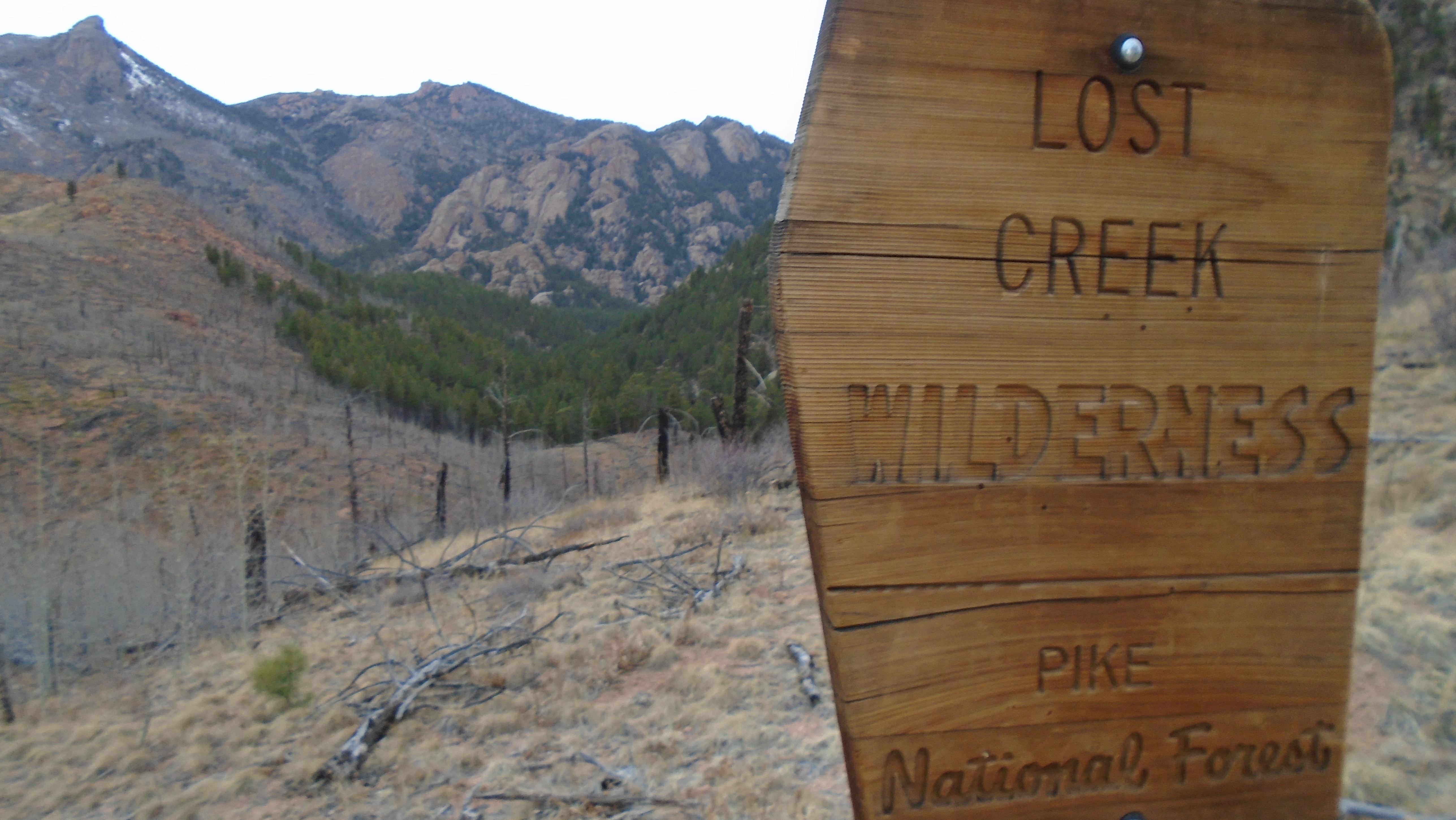
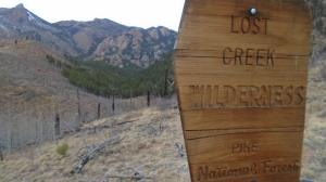
Work has been busy lately, so when I got invited to a series of meetings in Colorado Springs, I saw an opportunity and took it. I arranged to fly out a day early, and do a quick overnight somewhere in the Front Range between Denver and Colorado Springs. A little research led me to the Pike National Forest, Lost Creek Wilderness area, and the Goose Creek Trailhead.
Warning: the writeup below is longer than the typical blog musings. If you’d rather WATCH than read, the YouTube rendition of this trip is attached here. It’s also long, but captures the spirit of the trip. If you like this kind of thing, consider subscribing to my YouTube channel as well.
On the planning front, I had two concerns going in – first, the remoteness, second, the weather.
Weather was dismissed rather early – warm temps were scheduled to prevail, and I found a nice website with realtime snow depth reports that essentially indicated I’d be snow-free below about 10,000 feet. The only uncertainty would be translating lows in Denver (low 40’s) to realistic overnight temperature predictions in the mountains at roughly 9,000 feet – based on just elevation difference, I could expect anywhere from 12 to 20 deg F difference between my anticipated camp location and Denver. So probably not bitter, but certainly the possibility for temps well below freezing.
On the remoteness – I enjoy solo hiking and camping, but I’ve had enough situations over the years to recognize that solitude increases risk significantly. (See more on planning for risk mitigation in a coming post). In this case, I’d be in a remote Wilderness Area requiring 15 miles of dirt road driving to get to the trailhead, putting me completely off-grid, out of reach, and likely not to be found for some time. This is serious business, and requires some thought, planning and preparation. So most of my planning centered around that.
The easiest and most effective mitigation was to plan for some company, so I advertised the idea and found another traveler who was willing to embark on this journey. That alone, having a second set of eyes and ears, redundant gear, etc, really lowered the risk and made this trip feasible. Additionally, I looked at a couple front-country sites: Goose Creek Campground, a few miles from the trailhead, and Lone Rock Campground, near Deckers. Both would be backups in case flights were late, areas were closed, timing just didn’t work – essentially in case we had to abandon plans but still wanted or needed a night in a sleeping bag.
(BTW, in addition to all the usual sources on hiking/camping spots: AllTrails, Backpacker.com, local hiking group blog/posts, Google Earth… Nat Geo has a great free service for getting USGS quads, and the US Forest Service has topos for all their areas as well. Both were very helpful here in plotting out a course in an area I’d never seen.)
So with all those things in place, this was doable! I boresighted a potential camping spot on a plateau, near a creek crossing, near 9,000 feet somewhere above the intersection between Goose Creek Trail and McCurdy Park Trail, left detailed plans with my wife at home and a trusted partner at work, stuffed my backpack into a checked roller-bag, and departed for Colorado…
Location: Lost Creek Wilderness, in Pike National Forest, CO
Observations: So right off the bat, I was encouraged – my pack and gear actually made it to Colorado intact, stuffed into a checked roller-bag suitcase. My rental car turned out to be a Ford Explorer through luck of the draw, but needed on some of the remote dirt roads I’d be taking. I hit the WalMart close to Denver airport in Aurora, and got a fuel canister – unfortunately they didn’t have any small ones in stock so I had to grab twice as much as I thought I’d need, but whatever, small weight penalty.
It was 70 degrees in Denver. Amazing for this time of year.
The bad news (plans always change), my partner in crime for this trip had to cancel his trip – so I’d be solo. Bummer, but oh well, that’s what backup plans were for. I’d check things out and see.
After doing some work I headed out to the trailhead (about 3 hours from Denver airport). The last 45 minutes of that drive are through the area cleared by the Hayman Fire in 2002 – I can’t tell you how depressing it is to see, all the way to the horizon, complete destruction of the forest, and how 15 years later virtually nothing has returned (at least to my eye – I’m sure it’s recovering, but slowly). It was just shocking to me, the scale of it. Driving through this now-grassland and sometimes moonscape continued right up to the trailhead – requiring navigating lots of single-lane dirt roads and a couple tricky intersections. Most were marked with signs indicating Goose Creek, but I was still glad to have the in-dash GPS on the rental.
Goose Creek parking at the trailhead is plentiful, and though it was a Wed afternoon, it was popular. Three guys were loading up backpacks as I pulled in, and there were probably 6 other cars there. This gave me some confidence that though remote, I would have some chance of finding help if needed, so I continued with the original plan to go up the valley. It was still in the mid-60’s as I loaded up and headed out.
After pausing at the permit station (Permits are required for tracking usage, but are free – just fill in info on your plans, size of party, etc) and reading the trailhead info, I started DOWN, switchbacking through the burn area down to the creek. I didn’t expect to lose elevation right off the bat – but it didn’t last long. At the creek crossing (via log bridge) at the bottom, the trail splits into the Hankins Pass Trail, going west, and the Goose Creek Trail, going north and east.
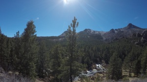
Shortly after this split, the Goose Creek Trail enters the forest, and the world changes completely, and suddenly. The transition from fire damage to still-healthy forest is sudden, and in my case plunging into shade, surrounded by the smells of conifers augmented by sap running on a late winter day, was very welcome.
The trail runs along the west side of Goose Creek for about a 1/4 mile, then crosses east on a nice steel bridge. There are plentiful campsites along the trail through this stretch, next to the creek. According to Wilderness Area rules, camping should be 100 feet from water, 100 feet from trails – but there were many well-established sites here that were clearly neither, and I doubt the rules were enforced for these sites. Seeing the availability of spots here made me start thinking about my logistics: My big constraint was getting back out on Thursday – I had to be back at the trailhead no later than 9am in order to make the drive to Colorado Springs and meet work obligations. So I didn’t want to go in any farther than 2-hours worth of hiking. Knowing there were some nice creek-side spots down low gave me options – I could essentially use any available daylight to day-hike (with a pack) as far up this valley as I wanted, and then come back DOWN to a campsite within that 2-hour hiking window. I like options… so I started keeping track of which was the “best” site I’d seen so far.
The creek itself was full of ice. Ice had accumulated in about a foot-wide belt along the shoreline, and all the still, deep pools were frozen over. Where the creek accelerated, it broke free from the ice and tumbled noisily over rocks. Very pretty. The whole valley is filled with a jumble of granite boulders and cliffs, with the rocks appearing to be more and more plentiful the higher up you go. Looking up the valley suggested a maze of boulder-hopping in my future. (That never happened).
After about 3/4 mile, (and seeing several hikers along the creek, including the 3 I saw from the trailhead who apparently intended to overnight by the creek), I came upon a signpost with no sign on it. One trail continued along the creek, and another veered right, east, up the hill. None of this is on any of the maps I had found, but knowing Goose Creek Trail was supposed to leave the creek and slab up the side of the eastern ridge, I guessed (correctly) that the right fork was the one I wanted.
Sure enough, the trail gained a couple hundred feet, but then paralleled the creek again – and from this vantage point, the views started to open up. GORGEOUS – blue cloudless sky, a forested valley with rock outcroppings everywhere, and a creek burbling along in the valley. There were frequent views of this along the trail as the canopy opened up, or from cliffs along the trail.
As I kept climbing, I noted that, even though I was paralleling a ridgeline, the trail would often have to climb and cross “shoulders” that ran out perpendicular to the main ridge. Each of these was fairly flat on top, and each looked like a possible campsite… I added them to my list.
Watching the clock, I just kept going, and the views kept changing – variety of rock formations made this very interesting, and not just looking at different spots in a green valley. As I suspected, I was not going to make my intended target at 9000 feet, or reach the intersection with the McCurdy Park Trail – with about 10 minutes left on my 2 hour limit, I came across an intersection with signs pointing to “Historic Buildings”. I wasn’t sure at the time, but have now confirmed what that was. Lost Creek is named because the creeks here flow in and out of the boulder fields, and occasionally disappear completely in caves, only to appear again 1/2-mile later. This happens several times through the course of the creek’s run. One entrepreneur in the early 1900s decided this was an ideal location, making use of the already-present rocks, to dam the creek and build a reservoir. Lucky for us, it didn’t work, but the side trail here leads to the old shaft house and other remnants of the effort in what is now named “Reservoir Gulch”.
So, with ten minutes to spare on the clock, I decided this was as good a place as any to define the upper limit of my camping area. GPS showed I was close to 5 miles in (turned out to be 4.3 – my GPS is great when you’re constantly moving, but when you stop, it continues to add up the dithering as your position changes 15 feet this way, then next. The net result is real-time overestimation of distance). Luckily, there was also a small stream at this intersection, so this affected my planning – I would drink my fill here, fill up from the stream, then head back down 1.5 miles or so to one of the “shoulders”, where I had seen a primo campsite with large flat rocks hanging out over the valley. I called it a “room with a view”. This approach left me a sheltered spot with a perch overlooking the valley, got me to a spot with daylight to spare (the sun was going to set behind the western ridge of the valley about an hour and a half before sunset proper), and would avoid the “cold sink” effect of camping by an icy creek in the bottom of the valley where cold air would accumulate overnight.
View from “My Rock”. Campsite is just out of frame behind me to the right.
My home for the night turned out to be perfect. An established fire ring became my kitchen (though I didn’t actually light a fire, given the dry conditions and fire ban notices I’d seen elsewhere), there was a little group of trees that made an inviting spot for my little tent, I found a great bear bag spot some distance away, and then there was my rock. A flat table of rock, about 50×75 feet – on “my” side, facing camp, I could scramble up on it by climbing about 6 feet and using a nearby tree. On the valley side, this rock was a 40-foot cliff. This rock became home for the night – I stood out here and marveled at the view, I came back here to eat dinner, I sat out here and watched the sun set, and the stars come out, and I lay out here and watched the Milky Way. This rock was my seat in a cathedral – quite possibly the quietest spot I’ve ever been (once the jet traffic into Denver settled down for the night) – I could hear the creek 700-feet below, I could hear one night bird somewhere out in the valley… and that was it, aside from the beating of my own heart and the faint ring in my own ears as they struggled to fill the emptiness with anything perceptible. It was starkly beautiful, peaceful, tranquil – and it also amplified my sense of solitude. I couldn’t have found a better spot…
The night passed that same way – quiet, no animal visitors, only the occasional puff of wind. Somewhere in the early dawn the temperature dropped noticeably, so that when my alarm went off at 6am, it was at or just below freezing. I attempted to start water for coffee in the dark, but it was too cold for the stove – it just couldn’t maintain pressure at this temperature, and put out what amounted to a candle flame. This is a known problem with canisters… Regardless, I let it do what it could while I packed up, and managed to have a tepid cup of coffee just as the first light was starting to show the valley face across to the west.
Dawn was gorgeous – low clouds had filled in just above my ridgelines, and they lit up in a fire of pink and orange as I hiked out. Every tree took on a pink glow for about 10 minutes, until the sun rose for real, and lit up the rocks across the valley in a morning alpenglow.
I made the trip back out rather quickly, passing a tent or two down along the creek. Per my suspicions, it HAD gotten colder along the creek – the air was noticeably colder, and there was more ice in the water than when I had come up the day before.
I was feeling very euphoric until the last half-mile, when I walked out of the trees and back into the burn area. I had almost forgotten this existed…it’s just so sad.
Anyway, plans worked. Back in the car at 8am and out to Colorado Springs in plenty of time. This was a BEAUTIFUL trip, a great getaway, and a great spot to put you in your place as a small inhabitant of a big world. Good for the soul! Extremely glad I got to do it, and very happy that the skills and experience I’ve accumulated allow me to do solo trips like this with confidence enough to enjoy them, rather than constantly worry about the what-ifs. Looking forward to the next adventure!
Thank you for the video and commentary. Truly enjoyed it and subscribed to your channel. I am planning a 4 night hike around the 27.6 mile Lost Creek loop in June of 2018. Planning on arrival of 22nd mid afternoon. Staying just right in from trailhead 1st night. Then hiking average 8 miles a day to completion. Any suggestions or advice? Thanks again and look forward to more videos.
Thanks for the subscription and the comments James, I appreciate your support! Sounds like you’re a pretty experienced guy to be planning a trip like this – I’m envious you have the opportunity to do it! I’ve barely scratched the surface on this area, I can only tell you that if you go in at Goose Creek, there are several nice campsites along the creek just in that first half mile that would serve your first-night objective really well. Just after you leave the burn area there’s a beautiful evergreen grove along the creek… I wish you the best, hope you have a great trip, and let me know how it goes! You going solo?
Actually I am novice at backpacking and hiking. Just enjoy challenging myself. I want spend time in solitude in a wilderness area to have reflections with God, my thoughts and nature. This is a time I will challenge myself and seek strength from within. I have experience in my military background serving in the Marines and Army National Guard. Happy thanksgiving and maybe sometime we can do a hiking adventure together.
In that case, with your military background I’m sure you understand and can deal with the physical challenge, and this is an excellent place for solitude and spirituality.
My only advice would be to make sure you’re keeping smellables (food, toothpaste, soap, etc) packed separate and keep your cooking area and bear bag away from your tent. There are both black bears and cougar in this area, but even a raccoon can ruin your day and this is pretty remote.
I have a Bear Vault 500 that I will be keeping a safe distance from my camp for all food. I will also be cooking away from my camp as you mentioned. Thank you for your insight.
 Weather was dismissed rather early – warm temps were scheduled to prevail, and I found a nice website with realtime snow depth reports that essentially indicated I’d be snow-free below about 10,000 feet. The only uncertainty would be translating lows in Denver (low 40’s) to realistic overnight temperature predictions in the mountains at roughly 9,000 feet – based on just elevation difference, I could expect anywhere from 12 to 20 deg F difference between my anticipated camp location and Denver. So probably not bitter, but certainly the possibility for temps well below freezing.
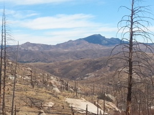
 Shortly after this split, the Goose Creek Trail enters the forest, and the world changes completely, and suddenly. The transition from fire damage to still-healthy forest is sudden, and in my case plunging into shade, surrounded by the smells of conifers augmented by sap running on a late winter day, was very welcome.
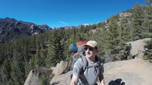 The creek itself was full of ice. Ice had accumulated in about a foot-wide belt along the shoreline, and all the still, deep pools were frozen over. Where the creek accelerated, it broke free from the ice and tumbled noisily over rocks. Very pretty. The whole valley is filled with a jumble of granite boulders and cliffs, with the rocks appearing to be more and more plentiful the higher up you go. Looking up the valley suggested a maze of boulder-hopping in my future. (That never happened).
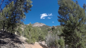 Sure enough, the trail gained a couple hundred feet, but then paralleled the creek again – and from this vantage point, the views started to open up. GORGEOUS – blue cloudless sky, a forested valley with rock outcroppings everywhere, and a creek burbling along in the valley. There were frequent views of this along the trail as the canopy opened up, or from cliffs along the trail.
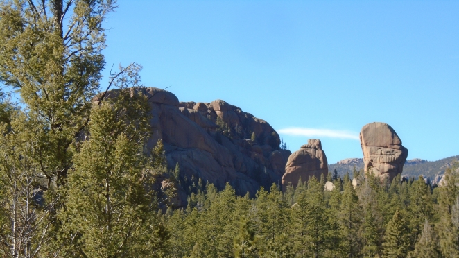 Watching the clock, I just kept going, and the views kept changing – variety of rock formations made this very interesting, and not just looking at different spots in a green valley. As I suspected, I was not going to make my intended target at 9000 feet, or reach the intersection with the McCurdy Park Trail – with about 10 minutes left on my 2 hour limit, I came across an intersection with signs pointing to “Historic Buildings”. I wasn’t sure at the time, but have now confirmed what that was. Lost Creek is named because the creeks here flow in and out of the boulder fields, and occasionally disappear completely in caves, only to appear again 1/2-mile later. This happens several times through the course of the creek’s run. One entrepreneur in the early 1900s decided this was an ideal location, making use of the already-present rocks, to dam the creek and build a reservoir. Lucky for us, it didn’t work, but the side trail here leads to the old shaft house and other remnants of the effort in what is now named “Reservoir Gulch”.
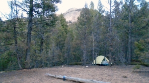 So, with ten minutes to spare on the clock, I decided this was as good a place as any to define the upper limit of my camping area. GPS showed I was close to 5 miles in (turned out to be 4.3 – my GPS is great when you’re constantly moving, but when you stop, it continues to add up the dithering as your position changes 15 feet this way, then next. The net result is real-time overestimation of distance). Luckily, there was also a small stream at this intersection, so this affected my planning – I would drink my fill here, fill up from the stream, then head back down 1.5 miles or so to one of the “shoulders”, where I had seen a primo campsite with large flat rocks hanging out over the valley. I called it a “room with a view”. This approach left me a sheltered spot with a perch overlooking the valley, got me to a spot with daylight to spare (the sun was going to set behind the western ridge of the valley about an hour and a half before sunset proper), and would avoid the “cold sink” effect of camping by an icy creek in the bottom of the valley where cold air would accumulate overnight.
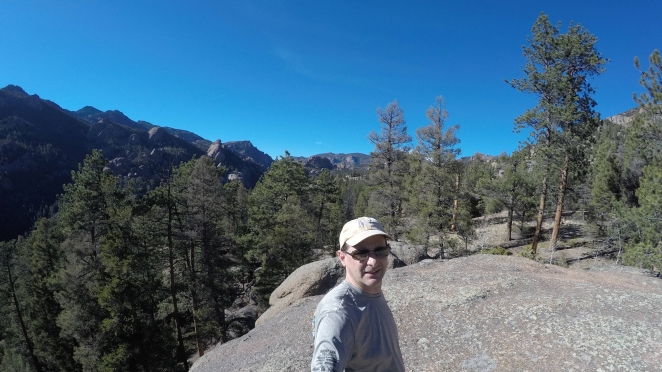


Nice pictures and narrative.
LikeLiked by 1 person
Thank you for the video and commentary. Truly enjoyed it and subscribed to your channel. I am planning a 4 night hike around the 27.6 mile Lost Creek loop in June of 2018. Planning on arrival of 22nd mid afternoon. Staying just right in from trailhead 1st night. Then hiking average 8 miles a day to completion. Any suggestions or advice? Thanks again and look forward to more videos.
LikeLiked by 1 person
Thanks for the subscription and the comments James, I appreciate your support! Sounds like you’re a pretty experienced guy to be planning a trip like this – I’m envious you have the opportunity to do it! I’ve barely scratched the surface on this area, I can only tell you that if you go in at Goose Creek, there are several nice campsites along the creek just in that first half mile that would serve your first-night objective really well. Just after you leave the burn area there’s a beautiful evergreen grove along the creek… I wish you the best, hope you have a great trip, and let me know how it goes! You going solo?
LikeLike
Hi Troy,
Actually I am novice at backpacking and hiking. Just enjoy challenging myself. I want spend time in solitude in a wilderness area to have reflections with God, my thoughts and nature. This is a time I will challenge myself and seek strength from within. I have experience in my military background serving in the Marines and Army National Guard. Happy thanksgiving and maybe sometime we can do a hiking adventure together.
James
LikeLike
In that case, with your military background I’m sure you understand and can deal with the physical challenge, and this is an excellent place for solitude and spirituality.
My only advice would be to make sure you’re keeping smellables (food, toothpaste, soap, etc) packed separate and keep your cooking area and bear bag away from your tent. There are both black bears and cougar in this area, but even a raccoon can ruin your day and this is pretty remote.
Have fun, and enjoy the journey!
LikeLike
I have a Bear Vault 500 that I will be keeping a safe distance from my camp for all food. I will also be cooking away from my camp as you mentioned. Thank you for your insight.
Best wishes!
LikeLiked by 1 person